
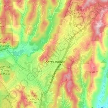
Scotts Valley topographic map
Interactive map
Click on the map to display elevation.
About this map
Name: Scotts Valley topographic map, elevation, terrain.
Average elevation: 203 m
Minimum elevation: 63 m
Maximum elevation: 332 m
Approximately ten thousand years ago there was a lake in the lowest elevation of Scotts Valley. Archeological excavations of site CA-SCR-177 (Scotts Valley Site) in 1983 and 1987 support dates for human settlement of this area as between 9,000 and 12,000 years before present (YBP). The lake drained during the Mid-Holocene warming period (4,000-5,000 YBP) forming what is now known as Carbonera Creek. When the lake drained, the people moved downslope following the lake water’s transformation as in became the creek. Around 2000 BC, Ohlone people occupied areas along the remaining creeks, spring and seep areas, along with permanent and seasonal drainages, and on flat ridges and terraces. Permanent villages were usually placed on elevations above seasonal flood levels. Surrounding areas were used for hunting and seed, acorn, and grass gathering. Therefore, areas along watercourses are considered likely locations for prehistoric cultural resources. Several watercourses, including portions of Carbonera Creek, Bean Creek, and MacKenzie Creek, are within the city.
Other topographic maps
Click on a map to view its topography, its elevation and its terrain.
Redwood Grove
United States > California > Santa Cruz County > Boulder Creek
Redwood Grove, Boulder Creek, Santa Cruz County, CAL Fire Northern Region, California, 95006, United States
Average elevation: 261 m