
Coleford topographic map
Interactive map
Click on the map to display elevation.
About this map
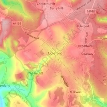
Name: Coleford topographic map, elevation, terrain.
Average elevation: 193 m
Minimum elevation: 82 m
Maximum elevation: 243 m
Other topographic maps
Click on a map to view its topography, its elevation and its terrain.
Upper Soudley
United Kingdom > England > Gloucestershire > Forest of Dean
Upper Soudley, Forest of Dean, Gloucestershire, England, GL14 2TS, United Kingdom
Average elevation: 138 m
St. Briavels
United Kingdom > England > Gloucestershire > Forest of Dean
St. Briavels, Forest of Dean, Gloucestershire, England, United Kingdom
Average elevation: 147 m
Aylburton
United Kingdom > England > Gloucestershire > Forest of Dean > Aylburton
Aylburton, Forest of Dean, Gloucestershire, England, United Kingdom
Average elevation: 37 m