
Maungatautari topographic map
Interactive map
Click on the map to display elevation.
About this map
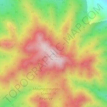
Name: Maungatautari topographic map, elevation, terrain.
Location: Maungatautari, Waipa District, Waikato, 3880, New Zealand (-38.01895 175.57593 -38.01885 175.57603)
Average elevation: 576 m
Minimum elevation: 320 m
Maximum elevation: 779 m
Waipa District trails, hiking, mountain biking, running and outdoor activities
Other topographic maps
Click on a map to view its topography, its elevation and its terrain.
Rangiaowhia War Memorial Domain
New Zealand > Waikato > Waipa District > Kihikihi > Rangiaowhia
Average elevation: 69 m