
Make a donation
Orlando topographic map
Click on the map to display elevation.
Make a donation
Orlando
According to the Köppen climate classification, Orlando has a humid subtropical climate (Cfa) like much of the deep Southern United States. The two basic seasons in Orlando are a hot and rainy season, lasting from May until late October (roughly coinciding with the Atlantic hurricane season), and a warm and dry season from November through April. The area's warm and humid climate is caused primarily by its low elevation, its position relatively close to the Tropic of Cancer, and its location in the center of a peninsula. Many characteristics of its climate are a result of its proximity to the Gulf Stream, which flows around the peninsula of Florida.
Make a donation
About this map
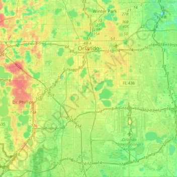
Name: Orlando topographic map, elevation, terrain.
Location: Orlando, Orange County, Florida, United States (28.34806 -81.50754 28.61428 -81.22759)
Average elevation: 30 m
Minimum elevation: 11 m
Maximum elevation: 58 m
Make a donation
Other topographic maps
Click on a map to view its topography, its elevation and its terrain.
Make a donation
Union Park
United States > Florida > Orange County
According to the United States Census Bureau, the CDP has a total area of 7.8 km2 (3.0 mi2), of which 7.7 km2 (3.0 mi2) is land and 0.1 km2 (0.04 mi2) (0.99%) is water. The elevation is 82 feet (25 m) above sea level.
Average elevation: 16 m
Make a donation
Orlando
United States > Florida > Orange County
According to the Köppen climate classification, Orlando has a humid subtropical climate (Cfa) like much of the deep Southern United States. The two basic seasons in Orlando are a hot and rainy season, lasting from May until late October (roughly coinciding with the Atlantic hurricane season), and a warm and…
Average elevation: 29 m
Make a donation
Make a donation
Make a donation
Make a donation
Union Park
United States > Florida > Orange County
According to the United States Census Bureau, the CDP has a total area of 7.8 km2 (3.0 mi2), of which 7.7 km2 (3.0 mi2) is land and 0.1 km2 (0.04 mi2) (0.99%) is water. The elevation is 82 feet (25 m) above sea level.
Average elevation: 16 m
Tildenville
United States > Florida > Orange County > Winter Garden > Tildenville
Average elevation: 29 m