
Los Angeles County topographic map
Interactive map
Click on the map to display elevation.
About this map
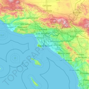
Name: Los Angeles County topographic map, elevation, terrain.
Location: Los Angeles County, California, United States of America (32.79693 -118.95172 34.82327 -117.64624)
Average elevation: 382 m
Minimum elevation: -3 m
Maximum elevation: 2,998 m
Other topographic maps
Click on a map to view its topography, its elevation and its terrain.
San Francisco
United States of America > California
Because of its sharp topography and maritime influences, San Francisco exhibits a multitude of distinct microclimates. The high hills in the geographic center of the city are responsible for a 20% variance in annual rainfall between different parts of the city. They also protect neighborhoods directly to their…
Average elevation: 57 m
San Diego County
United States of America > California
San Diego County has a varied topography. On its western side is more than 70 miles (110 km) of coastline. Most of San Diego between the coast and the Laguna Mountains consists of hills, mesas, and small canyons. Snow-capped (in winter) mountains rise to the east, with the Sonoran Desert farther to the east.…
Average elevation: 544 m
Lake County
United States of America > California
Lake County has a mediterranean climate with hot summer daytime temperatures in its lower elevations. Nighttime temperatures remain cool year-round, somewhat moderating average temperatures and relieving the summer heat.
Average elevation: 550 m
San Bruno Mountain
United States of America > California
San Bruno Mountain is topped by a four mile long ridge. Trails to the summit afford expansive views of the San Francisco Bay Area. Radio Peak (elevation 1,319 feet or 402 metres) is the highest point, hosting several radio broadcast towers, KTSF7 television, ION's KKPX television and NBC's KNTV television,…
Average elevation: 183 m
Kings County
United States of America > California
Table Mountain is the highest point in Kings County at an elevation of 3,476 feet (1,059 m). It is located in the Diablo Range in southwestern Kings County on the boundary between Kings and Monterey counties.
Average elevation: 101 m
Humboldt County
United States of America > California
The coastal zone of the county experiences very wet, cool winters and dry, mild foggy summers. In the winter, temperatures range from highs of 40–59 °F (4–15 °C) to lows of 32–49 °F (0–9 °C). Coastal summers are cool to mild, with average highs of 60–69 °F (16–21 °C) and frequent fogs.…
Average elevation: 540 m
Sacramento County
United States of America > California
According to the U.S. Census Bureau, the county has a total area of 994 square miles (2,570 km2), of which 965 square miles (2,500 km2) is land and 29 square miles (75 km2) (3.0%) is water. Most of the county is at an elevation close to sea level, with some areas below sea level. The highest point in the…
Average elevation: 62 m