Geolocate

Roraima topographic map

Interactive map

Click on the map to display elevation.

Roraima

Mount Roraima, located in Pacaraima Mountains, is the highest point in the state and one of the highest in the country, with 2,875 m (9,400 feet). The relief in the state is quite varied. Near the borders of Venezuela and Guyana are the mountains of Parima and Pacaraima, where Mount Roraima is located, with an altitude of 2,875 m (9,400 feet). As it is in the far north of Brazil, its points in the far north are the Uailan River and Mount Caburaí.

Wikipedia (CC-BY-SA 3.0)

About this map

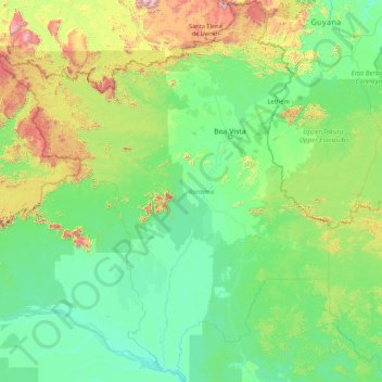
Name: Roraima topographic map, elevation, terrain.

Location: Roraima, North Region, Brazil (-1.59386 -64.82721 5.26958 -58.88600)

Average elevation: 260 m

Minimum elevation: 10 m

Maximum elevation: 2,784 m

Other topographic maps

Click on a map to view its topography, its elevation and its terrain.

Alto Garças

Brazil > Mato Grosso

Average elevation: 656 m

Espírito Santo

Brazil

The Captaincy of Espírito Santo was carved out of the Captaincy of Bahia in the 18th century, during the colonial rule of Brazil, and named after a 16th-century captaincy covering roughly the same area of coast. Following the elevation of Brazil to a constituent kingdom of United Kingdom of Portugal, Brazil…

Average elevation: 265 m

Curitiba

Brazil > Paraná > Região Metropolitana de Curitiba

The city covers 432.17 km2 (166.86 sq mi) on the First Plateau of Paraná. Curitiba has a topography of smooth, rounded hills, giving it a relatively regular shape. The city has an average altitude of 934.6 m (3,066 ft) above sea level. The highest point is to the north at 1,021 m (3,350 ft), and with lower…

Average elevation: 912 m

Corguinho

Brazil > Mato Grosso do Sul

Average elevation: 381 m

Parnamirim

Brazil > Rio Grande do Norte

Parnamirim belongs to the Intermediate Geographic Region of Natal and the Metropolitan Region of Natal. It is located on the coast with Atlantic Ocean, about 13 kilometers south of the urban center of Natal. Its average elevation is 48 meters above the sea level.

Average elevation: 48 m

Itaiçaba

Brazil > Ceará

Average elevation: 28 m

Nova Olímpia

Brazil > Mato Grosso

Average elevation: 258 m

Olegário Maciel

Brazil > Minas Gerais > Piranguinho

Average elevation: 872 m

Joanópolis

Brazil > São Paulo

Joanópolis is a municipality in the state of São Paulo in Brazil. The population is 13,338 (2020 est.) in an area of 374 km2. The elevation is 906 m.

Average elevation: 1,013 m

Espírito Santo do Pinhal

Brazil > São Paulo

Espírito Santo do Pinhal (Portuguese meaning "Holy Spirit of Pinhal") is a municipality in the state of São Paulo in Brazil. The population in 2020 is 44,471 (IBGE 2020) and the area is 389 km2. The elevation is 870 m.

Average elevation: 847 m

São Paulo

Brazil > São Paulo > Região Metropolitana de São Paulo

The city is on a plateau placed beyond the Serra do Mar (Portuguese for "Sea Range" or "Coastal Range"), itself a component of the vast region known as the Brazilian Highlands, with an average elevation of around 799 meters (2,621 ft) above sea level, although being at a distance of only about 70 kilometers…

Average elevation: 716 m

Ribeirão Preto

Brazil > São Paulo > Região Metropolitana de Ribeirão Preto

Ribeirão Preto is the eighth-largest municipality in the State with 650.9 km2 (251.3 sq mi). It has an estimated population of 720,216 in 2021 and a metropolitan area of 1,178,910. It is located 313 km (194 mi) from the city of São Paulo and 706 km (439 mi) from Brasília, the federal capital. Its mean…

Average elevation: 612 m

Valinhos

Brazil > São Paulo > Região Metropolitana de Campinas

Valinhos (Portuguese pronunciation: [vaˈliɲus]) is a municipality (município) in the state of São Paulo, Brazil. It is the birthplace of Adoniran Barbosa. Valinhos is famous for its purple fig, the theme of its annual Fig Fest. It is part of the Metropolitan Region of Campinas. The population is 131,210…

Average elevation: 729 m

Coronel Freitas

Brazil > Santa Catarina

Average elevation: 484 m

Entre Rios

Brazil > Santa Catarina

Average elevation: 539 m

Ouro

Brazil > Santa Catarina

Average elevation: 654 m

Rio Grande do Sul

Brazil

There are two highways, BR-290 and BR-472, running near the airport, besides a railroad line about 2,500 meters from the terminal. Located 9 km (6 mi) from the city center, this airport is at an elevation of 78 meters and the average annual temperature is 20C, with a good deal of variation from summer to…

Average elevation: 205 m

Salvador

Brazil > Bahia > Região Metropolitana de Salvador

Centralization as a capital, along with Portuguese colonization, were important factors in shaping the profile of the municipality, as were certain geographic characteristics. The construction of the city followed the uneven topography, initially with the formation of two levels—Upper Town (Cidade Alta) and…

Average elevation: 19 m

Fortaleza

Brazil > Ceará

Average elevation: 19 m

Galvão

Brazil > Santa Catarina

Average elevation: 743 m

Coronel Martins

Brazil > Santa Catarina

Average elevation: 640 m

C

Brazil > Santa Catarina > Xanxerê

Average elevation: 791 m

Santiago do Sul

Brazil > Santa Catarina

Average elevation: 565 m

São Domingos

Brazil > Santa Catarina

Average elevation: 718 m

Quilombo

Brazil > Santa Catarina

Average elevation: 491 m

Cordilheira Alta

Brazil > Santa Catarina

Average elevation: 647 m

Arvoredo

Brazil > Santa Catarina

Average elevation: 568 m

Xavantina

Brazil > Santa Catarina

Average elevation: 697 m

Ipumirim

Brazil > Santa Catarina

Average elevation: 754 m

Paial

Brazil > Santa Catarina

Average elevation: 438 m

Saudades

Brazil > Santa Catarina

Average elevation: 428 m

Ipuaçu

Brazil > Santa Catarina

Average elevation: 670 m

Sul Brasil

Brazil > Santa Catarina

Average elevation: 527 m

Lacerdópolis

Brazil > Santa Catarina

Average elevation: 623 m

Alto Bela Vista

Brazil > Santa Catarina

Average elevation: 501 m

Ipira

Brazil > Santa Catarina

Average elevation: 590 m

Campestre de Goiás

Brazil > Goiás

Average elevation: 646 m

Porto Alegre

Brazil > Rio Grande do Sul > Metropolitan Region of Porto Alegre

Porto Alegre has a long coastline on the Guaíba Lake, and its topography is punctuated by 40 hills. In the lake, a vast body of water, a maze of islands facing the city creates an archipelago where a unique ecosystem gives shelter to abundant wildlife. The city area concentrates 28% of the native flora of Rio…

Average elevation: 26 m

Porto Velho

Brazil > Rondônia

Average elevation: 125 m

Sarandi

Brazil > Rio Grande do Sul

Average elevation: 511 m

Paranaguá

Brazil > Paraná

Paranaguá experiences a humid subtropical climate (Köppen: Cfa), next to northern limit of the category in the southern hemisphere (border of the coast of São Paulo/Paraná). The coastal location and the Brazil current molds a climate different from the usual one of the interior of the Paraná. The summers…

Average elevation: 63 m

Florianópolis

Brazil > Santa Catarina

Florianópolis lies within the Atlantic Forest which has an extremely diverse and unique mix of vegetation and forest types. The main ecoregion is the coastal Atlantic forest, the narrow strip of about 50–100 kilometers (31–62 miles) along the coast which covers about 20 percent of the region. This forest…

Average elevation: 92 m

Municipal

Brazil > Rio Grande do Sul > Bento Gonçalves

Average elevation: 563 m

Alfredo Wagner

Brazil > Santa Catarina

Average elevation: 858 m

Londrina

Brazil > Paraná

Average elevation: 590 m

Serranópolis do Iguaçu

Brazil > Paraná

Average elevation: 272 m

Mercedes

Brazil > Paraná

Average elevation: 306 m