
Thank you for supporting this site ❤️
Make a donation
Make a donation
Wellington topographic map
Click on the map to display elevation.
Thank you for supporting this site ❤️
Make a donation
Make a donation
Wellington
Stretching for approximately 18 kilometers (11 miles), the pass rises to an altitude of 595 meters (1,952 feet) at its highest point. It winds through rugged mountains, offering spectacular vistas of the surrounding valleys, rivers, and fynbos-covered landscapes. The route is popular with tourists, cyclists, and nature enthusiasts who are drawn to its natural beauty and historical importance.
Thank you for supporting this site ❤️
Make a donation
Make a donation
About this map
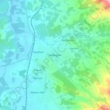
Name: Wellington topographic map, elevation, terrain.
Average elevation: 168 m
Minimum elevation: 82 m
Maximum elevation: 593 m
Thank you for supporting this site ❤️
Make a donation
Make a donation