
Thank you for supporting this site ❤️
Make a donation
Make a donation
Estância topographic map
Click on the map to display elevation.
Thank you for supporting this site ❤️
Make a donation
Make a donation
About this map
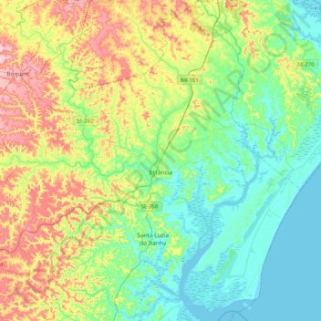
Name: Estância topographic map, elevation, terrain.
Location: Estância, Sergipe, Northeast Region, 49200-000, Brazil (-11.45863 -37.55624 -11.05309 -37.25906)
Average elevation: 55 m
Minimum elevation: -2 m
Maximum elevation: 175 m
Thank you for supporting this site ❤️
Make a donation
Make a donation
Other topographic maps
Click on a map to view its topography, its elevation and its terrain.