
Thank you for supporting this site ❤️
Make a donation
Make a donation
Begues topographic map
Click on the map to display elevation.
Thank you for supporting this site ❤️
Make a donation
Make a donation
About this map
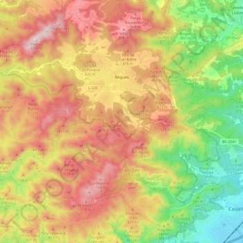
Name: Begues topographic map, elevation, terrain.
Location: Begues, Baix Llobregat, Barcelona, Catalonia, 08859, Spain (41.27823 1.84673 41.35582 1.96131)
Average elevation: 338 m
Minimum elevation: 3 m
Maximum elevation: 654 m
Thank you for supporting this site ❤️
Make a donation
Make a donation
Other topographic maps
Click on a map to view its topography, its elevation and its terrain.
Parc Forestal de l'Ermita del Pla de Sant Joan
Spain > Catalonia > Baix Llobregat > la Palma de Cervelló > Urbanització Can Vidal
Average elevation: 127 m
Thank you for supporting this site ❤️
Make a donation
Make a donation
Piug de Miramar
Spain > Catalonia > Baix Llobregat > Sant Climent de Llobregat
Average elevation: 100 m
Molins de Rei
Spain > Catalonia > Baix Llobregat > Molins de Rei > Molins de Rei
Average elevation: 117 m