
Thank you for supporting this site ❤️
Make a donation
Make a donation
Enfield topographic map
Click on the map to display elevation.
Thank you for supporting this site ❤️
Make a donation
Make a donation
About this map
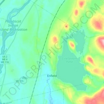
Name: Enfield topographic map, elevation, terrain.
Location: Enfield, Penobscot County, Maine, 04493, United States (45.21941 -68.65317 45.32818 -68.51230)
Average elevation: 76 m
Minimum elevation: 37 m
Maximum elevation: 222 m
Thank you for supporting this site ❤️
Make a donation
Make a donation
Other topographic maps
Click on a map to view its topography, its elevation and its terrain.
Spring Island
United States > Maine > Penobscot County > T4 Indian Purchase Township
Average elevation: 151 m