
Thank you for supporting this site ❤️
Make a donation
Make a donation
Pukekohe Hill topographic map
Click on the map to display elevation.
Thank you for supporting this site ❤️
Make a donation
Make a donation
About this map
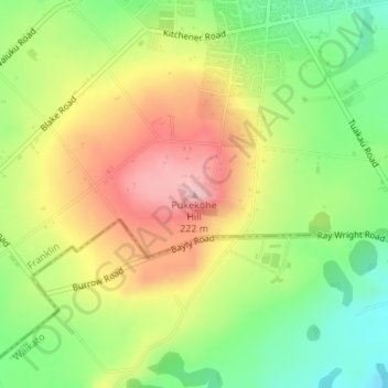
Name: Pukekohe Hill topographic map, elevation, terrain.
Location: Pukekohe Hill, Franklin, Auckland, 2120, New Zealand (-37.22896 174.89325 -37.22886 174.89335)
Average elevation: 126 m
Minimum elevation: 37 m
Maximum elevation: 224 m
Auckland trails, hiking, mountain biking, running and outdoor activities
Thank you for supporting this site ❤️
Make a donation
Make a donation