
Thank you for supporting this site ❤️
Make a donation
Make a donation
Harrisonburg topographic map
Click on the map to display elevation.
Thank you for supporting this site ❤️
Make a donation
Make a donation
About this map
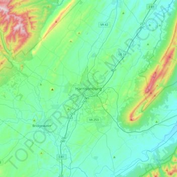
Name: Harrisonburg topographic map, elevation, terrain.
Location: Harrisonburg, Virginia, 22807, United States (38.28933 -79.02888 38.60933 -78.70888)
Average elevation: 446 m
Minimum elevation: 294 m
Maximum elevation: 1,126 m
Thank you for supporting this site ❤️
Make a donation
Make a donation
Other topographic maps
Click on a map to view its topography, its elevation and its terrain.
Virginia Beach
According to the United States Census Bureau, the city has a total area of 497 square miles (1,290 km2), of which 249 square miles (640 km2) is land and 248 square miles (640 km2) (49.9%) is water. It is the largest city in Virginia by total area and third-largest city by land area. The average elevation is 12…
Average elevation: 2 m
Thank you for supporting this site ❤️
Make a donation
Make a donation