
Thank you for supporting this site ❤️
Make a donation
Make a donation
Stainton topographic map
Click on the map to display elevation.
Thank you for supporting this site ❤️
Make a donation
Make a donation
About this map
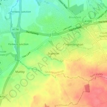
Name: Stainton topographic map, elevation, terrain.
Average elevation: 43 m
Minimum elevation: 10 m
Maximum elevation: 83 m
Thank you for supporting this site ❤️
Make a donation
Make a donation
Other topographic maps
Click on a map to view its topography, its elevation and its terrain.
Model of Cow Green Reservoir
United Kingdom > England > Middlesbrough > Middlesbrough
Average elevation: 33 m
Thank you for supporting this site ❤️
Make a donation
Make a donation