
Thank you for supporting this site ❤️
Make a donation
Make a donation
De Kalb topographic map
Click on the map to display elevation.
Thank you for supporting this site ❤️
Make a donation
Make a donation
About this map
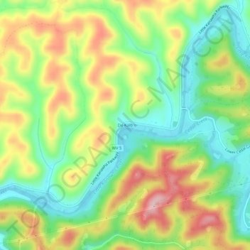
Name: De Kalb topographic map, elevation, terrain.
Location: De Kalb, Gilmer County, West Virginia, United States (38.92259 -80.95205 38.96259 -80.91205)
Average elevation: 294 m
Minimum elevation: 205 m
Maximum elevation: 412 m
Thank you for supporting this site ❤️
Make a donation
Make a donation
Other topographic maps
Click on a map to view its topography, its elevation and its terrain.