
Thank you for supporting this site ❤️
Make a donation
Make a donation
Kinango topographic map
Click on the map to display elevation.
Thank you for supporting this site ❤️
Make a donation
Make a donation
About this map
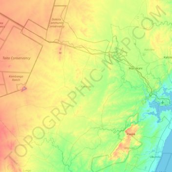
Name: Kinango topographic map, elevation, terrain.
Location: Kinango, Kwale, Coast, Kenya (-4.32637 38.76621 -3.57197 39.57632)
Average elevation: 254 m
Minimum elevation: -1 m
Maximum elevation: 769 m
Thank you for supporting this site ❤️
Make a donation
Make a donation
Other topographic maps
Click on a map to view its topography, its elevation and its terrain.