
Thank you for supporting this site ❤️
Make a donation
Make a donation
New Ash Green topographic map
Click on the map to display elevation.
Thank you for supporting this site ❤️
Make a donation
Make a donation
About this map
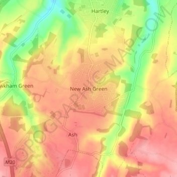
Name: New Ash Green topographic map, elevation, terrain.
Location: New Ash Green, Sevenoaks, Kent, England, DA3 8JF, United Kingdom (51.34574 0.28357 51.38574 0.32357)
Average elevation: 123 m
Minimum elevation: 62 m
Maximum elevation: 162 m
Thank you for supporting this site ❤️
Make a donation
Make a donation
Other topographic maps
Click on a map to view its topography, its elevation and its terrain.
Thank you for supporting this site ❤️
Make a donation
Make a donation
Sevenoaks Weald
United Kingdom > England > Kent > Sevenoaks > Sevenoaks Weald
Average elevation: 112 m
Thank you for supporting this site ❤️
Make a donation
Make a donation
Thank you for supporting this site ❤️
Make a donation
Make a donation
Thank you for supporting this site ❤️
Make a donation
Make a donation
Thank you for supporting this site ❤️
Make a donation
Make a donation
Thank you for supporting this site ❤️
Make a donation
Make a donation