
Kaeo topographic map
Click on the map to display elevation.
About this map
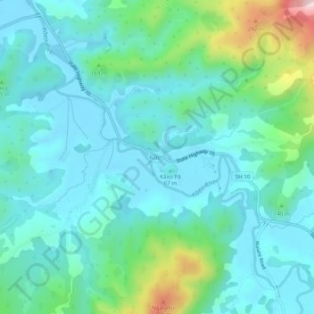
Name: Kaeo topographic map, elevation, terrain.
Average elevation: 75 m
Minimum elevation: -3 m
Maximum elevation: 377 m
Far North District trails, hiking, mountain biking, running and outdoor activities
Other topographic maps
Click on a map to view its topography, its elevation and its terrain.
Kaeo River
New Zealand > Northland > Far North District > Bay of Islands-Whangaroa Community
Average elevation: 121 m
Pungaere Stream
New Zealand > Northland > Far North District > Bay of Islands-Whangaroa Community
Average elevation: 183 m