
Thank you for supporting this site ❤️
Make a donation
Make a donation
Elk Point topographic map
Click on the map to display elevation.
Thank you for supporting this site ❤️
Make a donation
Make a donation
About this map
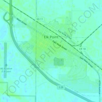
Name: Elk Point topographic map, elevation, terrain.
Average elevation: 343 m
Minimum elevation: 339 m
Maximum elevation: 348 m
Thank you for supporting this site ❤️
Make a donation
Make a donation
Other topographic maps
Click on a map to view its topography, its elevation and its terrain.
North Sioux City
United States > South Dakota > Union County > North Sioux City > North Sioux City
Average elevation: 353 m