Geolocate

El Nido topographic map

Click on the map to display elevation.

About this map

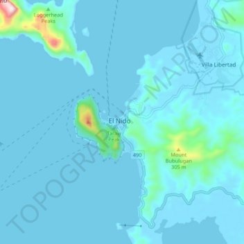
Name: El Nido topographic map, elevation, terrain.

Location: El Nido, Palawan, Mimaropa, 5313, Philippines (11.14001 119.35048 11.22001 119.43048)

Average elevation: 33 m

Minimum elevation: -3 m

Maximum elevation: 585 m

Other topographic maps

Click on a map to view its topography, its elevation and its terrain.

Corong Beach

Philippines > Palawan > El Nido

Average elevation: 50 m

Lio Beach

Philippines > Palawan > El Nido > Villa Libertad

Average elevation: 13 m

Coron Island

Philippines > Palawan > Coron

Average elevation: 37 m

Uson Island

Philippines > Palawan > Coron > Bancuan

Average elevation: 14 m

Malcapuya Island

Philippines > Palawan > Culion

Average elevation: 2 m

Malaroroy Island

Philippines > Palawan > Coron > Bulog

Average elevation: 2 m

Iloc Island

Philippines > Palawan > Linapacan

Average elevation: 23 m

Lake Manguao

Philippines > Palawan

Average elevation: 53 m

Iguana Island

Philippines > Palawan > Culion

Average elevation: 5 m

Pamalican Island

Philippines > Palawan > Cuyo

Average elevation: 1 m

Balabac Island

Philippines > Palawan

Average elevation: 20 m

Kalayaan

Philippines > Palawan

The islets that comprise the municipality are generally flat. The highest ground elevation is approximately two meters above sea level.

Average elevation: 0 m

Lagen Island

Philippines > Palawan

Average elevation: 44 m

Inabuyatan Island

Philippines > Palawan

Average elevation: 3 m

Shimizu Island

Philippines > Palawan

Average elevation: 18 m

Coron

Philippines > Palawan

Average elevation: 12 m

Dicilingan Island

Philippines > Palawan > Busuanga

Average elevation: 1 m

Horse Island

Philippines > Palawan > Busuanga

Average elevation: 1 m

Linapacan

Philippines > Palawan

Average elevation: 10 m

Cagayancillo

Philippines > Palawan

There are neither mountain ranges nor forested areas in the municipality. A hilly portion in the north-eastern part of the main island has a slope of 3-82%. The other areas are flat with the highest elevation around 2 to 3 meters. The majority of the island has a sandy loam soil not enough to support a forest.…

Average elevation: 0 m

Balabac

Philippines > Palawan

Average elevation: 2 m

Magsaysay

Philippines > Palawan

Average elevation: 1 m

Agutaya

Philippines > Palawan

Average elevation: 0 m