
Thank you for supporting this site ❤️
Make a donation
Make a donation
Knock Hill topographic map
Click on the map to display elevation.
Thank you for supporting this site ❤️
Make a donation
Make a donation
About this map
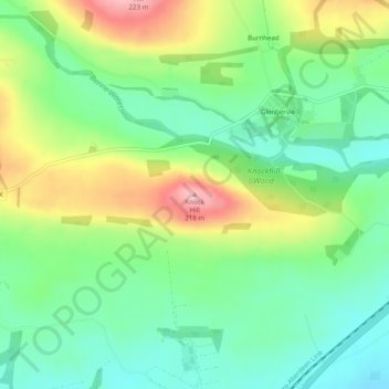
Name: Knock Hill topographic map, elevation, terrain.
Location: Knock Hill, Aberdeenshire, Scotland, AB39 3YB, United Kingdom (56.90994 -2.39541 56.91004 -2.39531)
Average elevation: 127 m
Minimum elevation: 74 m
Maximum elevation: 218 m
Thank you for supporting this site ❤️
Make a donation
Make a donation
Other topographic maps
Click on a map to view its topography, its elevation and its terrain.