
Thank you for supporting this site ❤️
Make a donation
Make a donation
Luquillo topographic map
Click on the map to display elevation.
Thank you for supporting this site ❤️
Make a donation
Make a donation
About this map
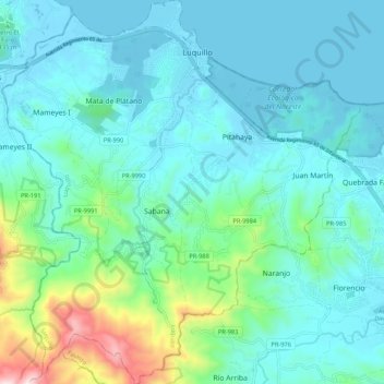
Name: Luquillo topographic map, elevation, terrain.
Location: Luquillo, Puerto Rico, United States (18.28797 -65.77055 18.38964 -65.66962)
Average elevation: 127 m
Minimum elevation: -1 m
Maximum elevation: 737 m
Thank you for supporting this site ❤️
Make a donation
Make a donation
Other topographic maps
Click on a map to view its topography, its elevation and its terrain.