
Thank you for supporting this site ❤️
Make a donation
Make a donation
Lemery topographic map
Click on the map to display elevation.
Thank you for supporting this site ❤️
Make a donation
Make a donation
About this map
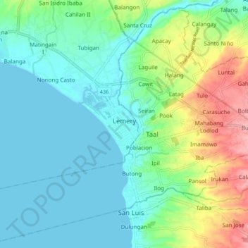
Name: Lemery topographic map, elevation, terrain.
Location: Lemery, Batangas, Calabarzon, 4208, Philippines (13.84457 120.87402 13.92457 120.95402)
Average elevation: 35 m
Minimum elevation: 0 m
Maximum elevation: 133 m
Thank you for supporting this site ❤️
Make a donation
Make a donation
Other topographic maps
Click on a map to view its topography, its elevation and its terrain.