
Thank you for supporting this site ❤️
Make a donation
Make a donation
Drury topographic map
Click on the map to display elevation.
Thank you for supporting this site ❤️
Make a donation
Make a donation
About this map
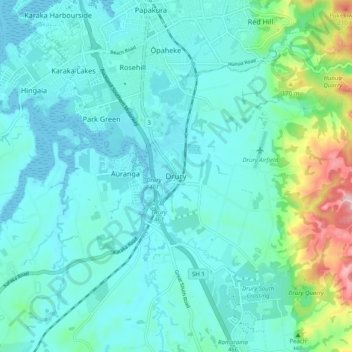
Name: Drury topographic map, elevation, terrain.
Location: Drury, Papakura, Auckland, 2113, New Zealand (-37.14207 174.91183 -37.06207 174.99183)
Average elevation: 46 m
Minimum elevation: 0 m
Maximum elevation: 273 m
Auckland trails, hiking, mountain biking, running and outdoor activities
Thank you for supporting this site ❤️
Make a donation
Make a donation
Other topographic maps
Click on a map to view its topography, its elevation and its terrain.