Geolocate

Arequipa topographic map

Interactive map

Click on the map to display elevation.

Arequipa

This department has a rough topography, which is characterised by heavy layers of volcanic lava covering large areas of its inter-Andean sector. It has deep canyons such as the ones formed by the Ocoña and Majes rivers. Plateaus range in height from medium, such as La Joya, and high-altitude ones such the Arrieros Pampa and those located in the zones of Chivay, Huambo and Pichucolla. Volcanic cones, such as Misti, Chachani, Ampato, Mismi, Solimana and Coropuna, emerge above the plateaus and attract snowfall. In contrast with these heights, there are deep canyons, including Majes, Colca, Sihuas and Ocoña, where important aspects of the ecological evolution of this zone can be clearly observed.

Wikipedia (CC-BY-SA 3.0)

About this map

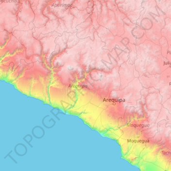
Name: Arequipa topographic map, elevation, terrain.

Location: Arequipa, Peru (-17.28501 -75.07199 -14.63274 -70.80408)

Average elevation: 2,599 m

Minimum elevation: 0 m

Maximum elevation: 6,195 m

Other topographic maps

Click on a map to view its topography, its elevation and its terrain.

Pachacámac

Peru > Lima > Lurín

Average elevation: 327 m

Cuzco

Peru > Cusco

Cusco or Cuzco (Spanish: [ˈkusko]; Quechua: Qosqo or Qusqu, pronounced [ˈqɔsqɔ]) is a city in southeastern Peru, near the Sacred Valley of the Andes mountain range and the Huatanay river. It is the capital of the eponymous province and department. The city is the seventh most populous in Peru; in 2017, it…

Average elevation: 3,790 m

Lajas

Peru > Cajamarca

Average elevation: 2,588 m

Chavez

Peru > Ica > Yauca del Rosario

Average elevation: 1,294 m

Cerro Miraflores

Peru > La Libertad > Huamachuco

Average elevation: 3,182 m

Soccoro

Peru > Apurímac > Huancarama

Average elevation: 3,053 m

Juliaca

Peru > Puno

Average elevation: 3,863 m

Raqaypata

Peru > Cusco > Santa Teresa

Average elevation: 2,972 m

La Libertad

Peru

Average elevation: 1,781 m

San Miguel de la Pascana

Peru > Ica

Average elevation: 406 m

Puerto Malabrigo

Peru > La Libertad > Rázuri

Average elevation: 17 m

Pico de Loro

Peru > Piura > Jililí

Average elevation: 1,187 m

Ancash

Peru

The park territory is very uneven. It has snowy summits, which altitudes vary between 5000 and 6768 MSL. It also has gullies, that are deeply encased because of the fluvioglacial erosion, and a great number of lagoons. Inside the borders of the park, there are 663 glaciers that are distributed throughout 180…

Average elevation: 2,121 m

Puno

Peru

Average elevation: 3,150 m

Madre de Dios

Peru

Average elevation: 501 m

City of Cuzco

Peru > Cusco > Cusco

Cusco or Cuzco ([ˈkusko]; Quechua: Qusqu ([ˈqɔsqɔ]), is a city in southeastern Peru near the Urubamba Valley of the Andes mountain range. It is the capital of the Cusco Region and of the Cusco Province. The city is the seventh most populous in Peru; in 2017, it had a population of 428,450. Its elevation is…

Average elevation: 3,453 m

Cochabamba

Peru > Ancash

Average elevation: 2,965 m

Oruro

Peru > Puno > Crucero

Average elevation: 4,335 m

Lima Metropolitan Area

Peru > Lima

Average elevation: 591 m

Province of San Marcos

Peru > Cajamarca

Average elevation: 2,783 m

Cauca

Peru > Puno > Macari

Average elevation: 4,405 m

Santa Fe

Peru > Loreto > Emilio San Martín

Average elevation: 103 m

Province of Carhuaz

Peru > Ancash

The Cordillera Blanca traverses the province. Waskaran, its highest elevation, lies on the border to the Yungay Province. Pallqarahu, Pukaranra, Qupa, Tuqllarahu, Wallqan and Yanarahu belong to the highest peaks of the province. Other mountains are listed below.

Average elevation: 4,038 m

Province of Lima

Peru > Lima > Lima Metropolitan Area

Average elevation: 1,234 m

San José del Monte

Peru > Lima > Mala

Average elevation: 188 m

Province of Recuay

Peru > Ancash

Average elevation: 2,661 m

Constitutional Province of Callao

Peru

Average elevation: 1,009 m

Mendoza

Peru > Ica

Average elevation: 127 m

Corao

Peru > Cusco > San Sebastián

Average elevation: 3,717 m

Regalado

Peru > Cajamarca > Tumbaden

Average elevation: 3,304 m

Maco

Peru > Junín > Tapo

Average elevation: 3,806 m

San Crispin

Peru > Pasco > Villa Rica

Average elevation: 2,192 m

Cabina

Peru > Ancash > Caraz > Rinconada

Average elevation: 2,481 m

Tambo

Peru > Ayacucho > Tambo

Average elevation: 3,780 m

Apurímac

Peru

Average elevation: 3,884 m

Machupicchu Pueblo

Peru > Cusco > Machupicchu > Machupicchu Pueblo

Average elevation: 2,494 m

Cauca

Peru > Arequipa > Cauca

Average elevation: 4,883 m

Callao

Peru > Callao

Average elevation: 21 m

Trujillo

Peru > La Libertad > Trujillo

Average elevation: 37 m

Piura

Peru

Topography is smooth in the coast and rough in the Sierra. There are many arid plains in the southern region. The Sechura Desert, located south of the Piura River, is Peru's largest desert and one of the world's few examples of a tropical desert; it borders a tropical terrain to the north. The Bayóvar…

Average elevation: 675 m

Ica

Peru

Ica has significant wine and pisco industries, annual fiestas, a museum and historic colonial churches. The climate is generally sunny and dry due to its elevation above coastal fog and mist. As of 2020, the Peruvian desert, around the Huacachina Oasis, has gotten significantly popular among tourists for…

Average elevation: 1,624 m

Caylloma

Peru > Arequipa > Caylloma

Average elevation: 4,544 m

Urubamba

Peru > Ayacucho > Urubamba

Average elevation: 3,332 m

Chorrillos

Peru > Lima > Chorrillos

Average elevation: 34 m

Cayma

Peru > Arequipa > Cayma

Average elevation: 3,736 m

Ciudad Satélite

Peru > Junín > Ciudad Satélite

Average elevation: 768 m

Pueblo Libre

Peru > San Martín > Pueblo Libre

Average elevation: 842 m

Machupicchu

Peru > Cusco > Machupicchu

Average elevation: 3,640 m