
Cela Velha topographic map
Interactive map
Click on the map to display elevation.
About this map
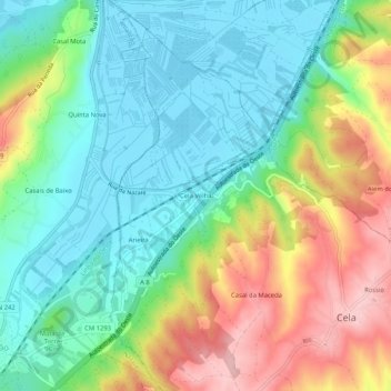
Name: Cela Velha topographic map, elevation, terrain.
Location: Cela Velha, Cela, Alcobaça, Leiria, 2450-015, Portugal (39.53235 -9.07550 39.57235 -9.03550)
Average elevation: 66 m
Minimum elevation: -1 m
Maximum elevation: 185 m
Other topographic maps
Click on a map to view its topography, its elevation and its terrain.
Casal do Ramos
Portugal > Leiria > Alcobaça > Cela
Casal do Ramos, Cela, Alcobaça, Leiria, 2460-760, Portugal
Average elevation: 95 m