
Make a donation
Padre Burgos topographic map
Click on the map to display elevation.
Make a donation
About this map
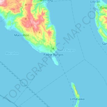
Name: Padre Burgos topographic map, elevation, terrain.
Location: Padre Burgos, Southern Leyte, Eastern Visayas, Philippines (9.90608 124.92134 10.15966 125.09185)
Average elevation: 38 m
Minimum elevation: 0 m
Maximum elevation: 504 m
Make a donation
Other topographic maps
Click on a map to view its topography, its elevation and its terrain.
Mount Cabalian
The stratovolcano has an elevation of 945 metres (3,100 ft) with a base diameter of 8.5 kilometres (5.3 mi). The predominant rock type is andesite. Beside solfataras, other thermal features present are hot springs located on the east and west flank of the volcano. Mainit Hot Spring in the municipality of…
Average elevation: 524 m
Make a donation
Make a donation
Make a donation
Make a donation
Dirt Riders Southern Leyte Usay Lubi
Philippines > Southern Leyte > Milagroso
Average elevation: 301 m
Make a donation
Make a donation
Hinunangan
Hinunangan is home to the highest mountain in the province, Mount Nacolod, with an elevation of 948 metres (3,110 ft) above sea level.
Average elevation: 35 m
Make a donation
Mount Cabalian
The stratovolcano has an elevation of 945 metres (3,100 ft) with a base diameter of 8.5 kilometres (5.3 mi). The predominant rock type is andesite. Beside solfataras, other thermal features present are hot springs located on the east and west flank of the volcano. Mainit Hot Spring in the municipality of…
Average elevation: 524 m
Make a donation
Make a donation
Sogod
On May 18, 1700, the colonial government of the Philippines established Sogod as a regular visita [satellite barrio with chapel]. With this elevation, a concrete church finally stood in the settlement in the year 1718. The construction was made possible through the mandate of the Most Reverend Sebastian…
Average elevation: 94 m