
Salvador Benedicto topographic map
Interactive map
Click on the map to display elevation.
Salvador Benedicto
Although a small town, the town of Don Salvador Benedicto has seen a rise in its municipal economy thanks to tourism and local agriculture. Due to its high altitude like Baguio, the town can support crops that grow in temperate areas, making it ideal for a multitude of farming businesses. Tourism is on the rise for the town especially when travellers head out into the heart of the province. Also located in the municipality are the Choco Hills, similar to Bohol's Chocolate Hills, with shared boundary of Barangay Prosperidad, San Carlos City.
About this map
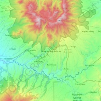
Name: Salvador Benedicto topographic map, elevation, terrain.
Average elevation: 708 m
Minimum elevation: 141 m
Maximum elevation: 1,853 m
Other topographic maps
Click on a map to view its topography, its elevation and its terrain.
Mount Kanlaon
Philippines > Negros Occidental
Kanlaon, also known as Mount Kanlaon and Kanlaon Volcano (Hiligaynon: Bolkang Kanglaon; Cebuano: Bolkang Kanglaon; Filipino: Bulkang Kanlaon), is an active stratovolcano and the highest mountain on the island of Negros in the Philippines, as well as the highest point in the Visayas, with an elevation of 2,465…
Average elevation: 1,920 m