Geolocate

Bansalan topographic map

Interactive map

Click on the map to display elevation.

About this map

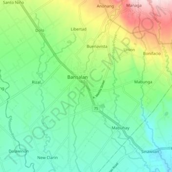
Name: Bansalan topographic map, elevation, terrain.

Location: Bansalan, Davao del Sur, Davao Region, Philippines (6.74270 125.17486 6.82270 125.25486)

Average elevation: 157 m

Minimum elevation: 33 m

Maximum elevation: 441 m

Other topographic maps

Click on a map to view its topography, its elevation and its terrain.

Mount Apo

Philippines > Davao del Sur > Bansalan

Mount Apo, also known locally as Apo Sandawa, is a large solfataric, dormant stratovolcano on the island of Mindanao, Philippines. With an elevation of 2,954 meters (9,692 ft) above sea level, it is the highest-mountain in the Philippine Archipelago, Mindanao and 24th-highest peak of an island on Earth.…

Average elevation: 2,416 m