
Make a donation
Tbilisi topographic map
Click on the map to display elevation.
Make a donation
Tbilisi
Most of the raions are named after historic quarters of the city. The citizens of Tbilisi widely recognise an informal system of smaller historic neighbourhoods. Such neighbourhoods are several, however, constituting a kind of hierarchy, because most of them have lost their distinctive topographic limits. The natural first level of subdivision of the city is into the Right Bank and the Left Bank of the Mt'k'vari. The names of the oldest neighbourhoods go back to the early Middle Ages and sometimes pose a great linguistic interest. The newest whole-built developments bear chiefly residential marketing names.
Make a donation
About this map
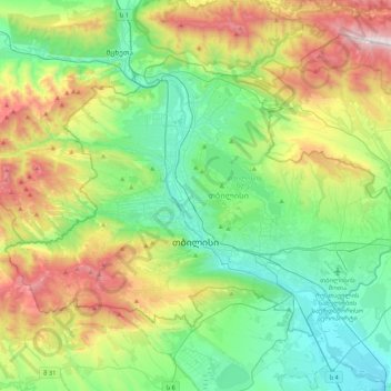
Name: Tbilisi topographic map, elevation, terrain.
Location: Tbilisi, Georgia (41.61779 44.59620 41.84388 45.01729)
Average elevation: 756 m
Minimum elevation: 330 m
Maximum elevation: 1,713 m
Make a donation
Other topographic maps
Click on a map to view its topography, its elevation and its terrain.
Caucasus Mountains
Georgia > Mtskheta-Mtianeti > Dusheti Municipality > Chalisopeli
The climate of the Caucasus varies both vertically (according to elevation) and horizontally (by latitude and location). Temperature generally decreases as elevation rises. Average annual temperature in Sukhumi, Abkhazia at sea level is 15 °C (59 °F) while on the slopes of Mt.Kazbek at an elevation of 3,700…
Average elevation: 2,188 m
Chukuli
Georgia > Racha-Lechkhumi and Kvemo Svaneti > Lentekhi Municipality
Average elevation: 1,595 m
Make a donation
Gudauri
Georgia > Mtskheta-Mtianeti > Kazbegi Municipality
Gudauri (Georgian: გუდაური) is a ski resort located on the south-facing plateau of The Greater Caucasus Mountain Range in Georgia. The resort is situated in the Stepantsminda District, along the Georgian Military Highway near the Jvari Pass, at an elevation of 2,200 meters (7,200 ft.) above sea…
Average elevation: 2,161 m
Make a donation
Ushguli
Georgia > Samegrelo-Upper Svaneti > Mestia Municipality
Ushguli is located at an altitude of 2,100 metres (6,900 ft) near the foot of Shkhara, one of the highest summits of the Greater Caucasus mountains. About 70 families (about 200 people) live in the area, enough to support a small school. The area is snow-covered for 6 months of the year, and often the road to…
Average elevation: 2,409 m
Paravani
Georgia > Samtskhe-Javakheti > Ninotsminda Municipality > Patara Arakali
Average elevation: 1,989 m
Make a donation
Make a donation
Mtskheta — Stepantsminda — Larsi
Georgia > Mtskheta-Mtianeti > Kazbegi Municipality > Gudauri
Average elevation: 2,284 m
Darial Gorge
Georgia > Mtskheta-Mtianeti > Kazbegi Municipality
The Russian fort, Darial, which guarded this section of the Georgian Military Road, was built at the northern end of the gorge, at an altitude of 1,447 metres (4,747 ft).
Average elevation: 1,783 m
Gudauri
Georgia > Mtskheta-Mtianeti > Kazbegi Municipality
Gudauri (Georgian: გუდაური) is a ski resort located on the south-facing plateau of The Greater Caucasus Mountain Range in Georgia. The resort is situated in the Kazbegi Municipality, along the Georgian Military Highway near the Jvari Pass, at an elevation of 2,200 meters (7,200 ft.) above sea…
Average elevation: 2,161 m
Make a donation
Caucasus Mountains
Georgia > Mtskheta-Mtianeti > Dusheti Municipality > Chalisopeli
The climate of the Caucasus varies both vertically (according to elevation) and horizontally (by latitude and location). Temperature generally decreases as elevation rises. Average annual temperature in Sokhumi, Abkhazia at sea level is 15 °C (59 °F) while on the slopes of Mt.Kazbek at an elevation of 3,700…
Average elevation: 2,188 m
Make a donation
Senaki
Georgia > Samegrelo-Upper Svaneti > Senaki Municipality
Senaki (Georgian: სენაკი; Mingrelian: სანაკი) is a town in Samegrelo-Zemo Svaneti region, western Georgia. It is located at around 42°16′8″N 42°4′45″E / 42.26889°N 42.07917°E / 42.26889; 42.07917 between the rivers Tekhura/i and Tsivi, at an elevation of 28–38…
Average elevation: 80 m
Make a donation
Caucasus Mountains
Georgia > Mtskheta-Mtianeti > Dusheti Municipality > Chalisopeli
The climate of the Caucasus varies both vertically (according to elevation) and horizontally (by latitude and location). Temperature generally decreases as elevation rises. Average annual temperature in Sukhumi, Abkhazia at sea level is 15 °C (59 °F) while on the slopes of Mt.Kazbek at an elevation of 3,700…
Average elevation: 2,188 m
Kakheti
Vineyards in Kakheti are typically cultivated at elevations of approximately 400–700 metres above sea level. The region encompasses a range of climatic zones, including humid subtropical and steppe climates, as well as semi-arid plains and subalpine areas. These environmental conditions contribute to the…
Average elevation: 1,035 m
Make a donation
Make a donation
Green Lake
Georgia > Racha-Lechkhumi and Kvemo Svaneti > Tsageri Municipality
Average elevation: 1,139 m
Make a donation
Tbilisi
Most of the raions are named after historic quarters of the city. The citizens of Tbilisi widely recognise an informal system of smaller historic neighbourhoods. Such neighbourhoods are several, however, constituting a kind of hierarchy, because most of them have lost their distinctive topographic limits. The…
Average elevation: 713 m
Jvari
Georgia > Samegrelo-Upper Svaneti > Tsalenjikha Municipality
Jvari (Georgian: ჯვარი) is a town in the northwestern Georgian province of Samegrelo-Zemo Svaneti. The town is situated at an altitude of 280 metres near the Magana River where it flows into the Enguri River; The town is divided in two with "Jvari" lying on the Zugdidi-Mestia highway, and Jvarzeni…
Average elevation: 450 m
Bakuriani
Georgia > Samtskhe-Javakheti > Borjomi Municipality
Bakuriani (Georgian: ბაკურიანი) is a daba and a ski resort in the Borjomi district of Georgia. It is located on the northern slope of the Trialeti Range, at an elevation of 1,700 meters (5,576 feet) above sea level.
Average elevation: 1,756 m
Make a donation
Buba Glacier
Georgia > Racha-Lechkhumi and Kvemo Svaneti > Oni Municipality
Average elevation: 3,398 m
Make a donation
Kveda Sairme
Georgia > Racha-Lechkhumi and Kvemo Svaneti > Tsageri Municipality
Average elevation: 669 m
Make a donation
Bakuriani
Georgia > Samtskhe-Javakheti > Borjomi Municipality
Bakuriani (Georgian: ბაკურიანი) is a daba and a ski resort in the Borjomi district of Georgia. It is located on the northern slope of the Trialeti Range, at an elevation of 1,700 meters (5,576 feet) above sea level.
Average elevation: 1,756 m
Make a donation
Nokalakevi (Tsikhegoji)
Georgia > Samegrelo-Upper Svaneti > Senaki Municipality > Gakhomela
Average elevation: 158 m
Make a donation
Mestia
Georgia > Samegrelo-Upper Svaneti > Mestia Municipality
Mestia (Georgian: მესტია IPA: [mestʼia]) is a highland townlet (daba) in northwest Georgia, at an elevation of 1,500 metres (4,921 feet) in the Caucasus Mountains.
Average elevation: 1,761 m
Senaki
Georgia > Samegrelo-Upper Svaneti > Senaki Municipality
Senaki (Georgian: სენაკი, senak'i; Mingrelian: სანაკი, sanak'i) is a city in Samegrelo-Zemo Svaneti region, western Georgia. It is located at around 42°16′8″N 42°4′45″E / 42.26889°N 42.07917°E / 42.26889; 42.07917 between the rivers Tekhura/i and Tsivi, at an…
Average elevation: 80 m
Make a donation
Murmaneti
Georgia > Autonomous Republic of Adjara > Khelvachauri Municipality
Average elevation: 153 m
Make a donation
Shemokmedi
Georgia > Guria > Ozurgeti Municipality
Shemokmedi (Georgian: შემოქმედი) is a village in the Ozurgeti Municipality, Guria, Georgia. It is located in western Georgia, on the Bzhuzhi river, at elevation of 190 m above sea level, 7 km east of the city of Ozurgeti. The village is home to the late medieval Shemokmedi Monastery.
Average elevation: 181 m
Make a donation
Mirveti Waterfall
Georgia > Autonomous Republic of Adjara > Khelvachauri Municipality > Mirveti
Average elevation: 297 m
Make a donation
Make a donation
Very steep, dangerous route
Georgia > Samegrelo-Upper Svaneti > Mestia Municipality
Average elevation: 1,875 m
Make a donation
Make a donation
Tbilisa Glacier
Georgia > Racha-Lechkhumi and Kvemo Svaneti > Oni Municipality
Average elevation: 3,443 m
Make a donation
Mestia
Georgia > Samegrelo-Upper Svaneti > Mestia Municipality
Mestia (Georgian: მესტია IPA: [mestʼia]) is a highland townlet (daba) in northwest Georgia, at an elevation of 1,500 metres (4,921 feet) in the Caucasus Mountains.
Average elevation: 1,761 m
Make a donation
Mtirala
Georgia > Autonomous Republic of Adjara > Khelvachauri Municipality
Average elevation: 1,000 m
Bakuriani
Georgia > Samtskhe-Javakheti > Borjomi Municipality
Bakuriani (Georgian: ბაკურიანი) is a daba and a ski resort in the Borjomi district of Georgia. It is located on the northern slope of the Trialeti Range, at an elevation of 1,700 meters (5,576 feet) above sea level.
Average elevation: 1,756 m
Make a donation