
Scranton topographic map
Interactive map
Click on the map to display elevation.
Scranton
Center City is about 750 feet (229 m) above sea level, although the hilly city's inhabited portions range about from 650 to 1,400 feet (200 to 430 m). The city is flanked by mountains to the east and west whose elevations range from 1,900 to 2,100 feet (580 to 640 m).
About this map
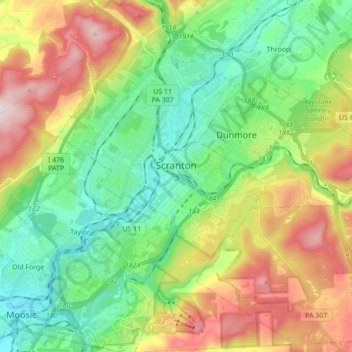
Name: Scranton topographic map, elevation, terrain.
Location: Scranton, Lackawanna County, Pennsylvania, United States (41.33963 -75.72002 41.46933 -75.60387)
Average elevation: 360 m
Minimum elevation: 183 m
Maximum elevation: 675 m