
Thank you for supporting this site ❤️
Make a donation
Make a donation
Hainan Island topographic map
Click on the map to display elevation.
Thank you for supporting this site ❤️
Make a donation
Make a donation
About this map
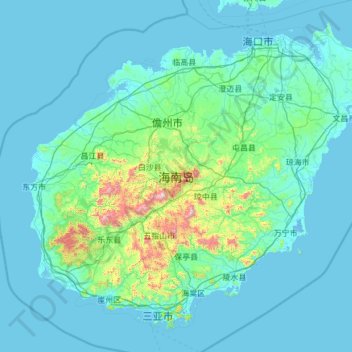
Name: Hainan Island topographic map, elevation, terrain.
Location: Hainan Island, Hainan, China (18.15920 108.61254 20.16251 111.04233)
Average elevation: 98 m
Minimum elevation: -3 m
Maximum elevation: 1,768 m
Thank you for supporting this site ❤️
Make a donation
Make a donation
Other topographic maps
Click on a map to view its topography, its elevation and its terrain.