
Thank you for supporting this site ❤️
Make a donation
Make a donation
Piraera topographic map
Click on the map to display elevation.
Thank you for supporting this site ❤️
Make a donation
Make a donation
About this map
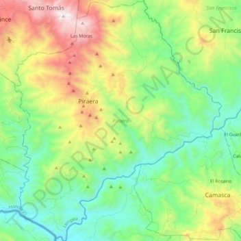
Name: Piraera topographic map, elevation, terrain.
Location: Piraera, Lempira, Honduras (13.96332 -88.53014 14.13727 -88.37585)
Average elevation: 613 m
Minimum elevation: 68 m
Maximum elevation: 1,734 m
Thank you for supporting this site ❤️
Make a donation
Make a donation
Other topographic maps
Click on a map to view its topography, its elevation and its terrain.