
Opaky topographic map
Click on the map to display elevation.
About this map
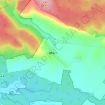
Name: Opaky topographic map, elevation, terrain.
Average elevation: 331 m
Minimum elevation: 272 m
Maximum elevation: 454 m
Other topographic maps
Click on a map to view its topography, its elevation and its terrain.
Lviv
Lviv is on the edge of the Roztochia Upland, about 70 kilometres (43 miles) east of the Polish border and 160 km (99 mi) north of the eastern Carpathian Mountains. The average altitude of Lviv is 296 metres (971 feet) above sea level. Its highest point is the Vysokyi Zamok (High Castle), 409 meters (1,342…
Average elevation: 309 m