
Carlisle topographic map
Click on the map to display elevation.
About this map
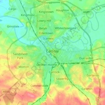
Name: Carlisle topographic map, elevation, terrain.
Location: Carlisle, Cumberland, England, United Kingdom (54.85565 -2.98940 54.93207 -2.87749)
Average elevation: 31 m
Minimum elevation: 5 m
Maximum elevation: 75 m
Other topographic maps
Click on a map to view its topography, its elevation and its terrain.
Hardknott Pass
United Kingdom > England > Cumberland > Ulpha
The Hardknott Pass stands at a maximum elevation of 393 m (1,289 ft). The road descends steeply at a gradient of 30% (1 in 3) into the Duddon Valley. At the eastern end of the pass is Cockley Beck farm, built in the 1860s and owned by the National Trust. The route from Hardknott leads eastward towards the…
Average elevation: 323 m