
Republik Krim topographic map
Interactive map
Click on the map to display elevation.
About this map
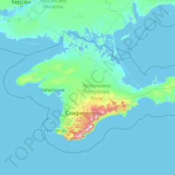
Name: Republik Krim topographic map, elevation, terrain.
Location: Republik Krim, Föderationskreis Südrussland, Russland, Krim (44.38641 32.47975 46.18059 36.64705)
Average elevation: 35 m
Minimum elevation: -5 m
Maximum elevation: 1,514 m
Other topographic maps
Click on a map to view its topography, its elevation and its terrain.
Бомборы
Russland > Sewastopol > Sewastopol
Бомборы, Bezirk Nachimow, Sewastopol, Föderationskreis Südrussland, Russland
Average elevation: 56 m
Sewastopol
Russland > Sewastopol > Sewastopol
Sewastopol, Föderationskreis Südrussland, 299000-299699, Russland
Average elevation: 68 m