
Свилајнац topographic map
Interactive map
Click on the map to display elevation.
About this map
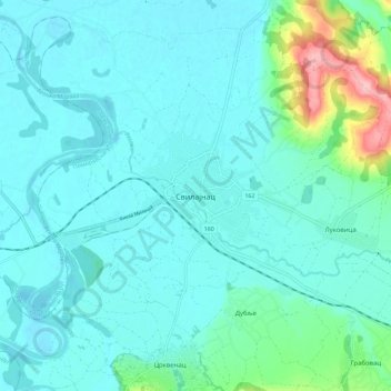
Name: Свилајнац topographic map, elevation, terrain.
Average elevation: 115 m
Minimum elevation: 92 m
Maximum elevation: 245 m
Svilajnac est située sur les bords de la rivière Resava, à 100 km au sud-est de Belgrade. Le territoire de la municipalité, quant à lui, se trouve dans la région géographique de la basse Resava et s'étend sur 326 km2. Avec une altitude comprise entre 100 m et 389 m, la municipalité possèdent de nombreuses terres favorables à l'agriculture.
Other topographic maps
Click on a map to view its topography, its elevation and its terrain.
Бобово
Serbie > Serbie centrale > Поморавски управни округ > Општина Свилајнац
Бобово, Општина Свилајнац, Поморавски управни округ, Serbie centrale, 35217, Serbie
Average elevation: 179 m