
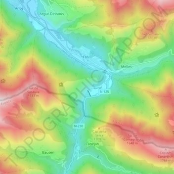
Fos topographic map
Interactive map
Click on the map to display elevation.
About this map
Name: Fos topographic map, elevation, terrain.
Average elevation: 1,050 m
Minimum elevation: 512 m
Maximum elevation: 1,879 m
Other topographic maps
Click on a map to view its topography, its elevation and its terrain.
Arbon
France > Occitania > Haute-Garonne
Arbon, Saint-Gaudens, Haute-Garonne, Occitania, Metropolitan France, 31160, France
Average elevation: 581 m
Salies-du-Salat
France > Occitania > Haute-Garonne
Salies-du-Salat, Saint-Gaudens, Haute-Garonne, Occitania, Metropolitan France, 31260, France
Average elevation: 335 m
Eup
France > Occitania > Haute-Garonne
Eup, Saint-Gaudens, Haute-Garonne, Occitania, Metropolitan France, 31440, France
Average elevation: 738 m
L'Isle-en-Dodon
France > Occitania > Haute-Garonne
L'Isle-en-Dodon, Saint-Gaudens, Haute-Garonne, Occitania, Metropolitan France, 31230, France
Average elevation: 244 m
Saint-Béat
France > Occitania > Haute-Garonne > Saint-Béat-Lez
Saint-Béat, Saint-Béat-Lez, Saint-Gaudens, Haute-Garonne, Occitania, Metropolitan France, 31440, France
Average elevation: 872 m
Cazères
France > Occitania > Haute-Garonne
Cazères, Muret, Haute-Garonne, Occitania, Metropolitan France, 31220, France
Average elevation: 267 m
Mane
France > Occitania > Haute-Garonne
Mane, Saint-Gaudens, Haute-Garonne, Occitania, Metropolitan France, 31260, France
Average elevation: 338 m
Bourg-Saint-Bernard
France > Occitania > Haute-Garonne
Bourg-Saint-Bernard, Toulouse, Haute-Garonne, Occitania, Metropolitan France, 31570, France
Average elevation: 197 m
Grand-Noble
France > Occitania > Haute-Garonne > Blagnac
Grand-Noble, Blagnac, Toulouse, Haute-Garonne, Occitania, Metropolitan France, 31700, France
Average elevation: 141 m
Ore
France > Occitania > Haute-Garonne
Ore, Saint-Gaudens, Haute-Garonne, Occitania, Metropolitan France, 31510, France
Average elevation: 530 m
Carbonne
France > Occitania > Haute-Garonne
Carbonne, Muret, Haute-Garonne, Occitania, Metropolitan France, 31390, France
Average elevation: 232 m
Mirambeau
France > Occitania > Haute-Garonne
Mirambeau, Saint-Gaudens, Haute-Garonne, Occitania, Metropolitan France, 31230, France
Average elevation: 230 m
Lavalette
France > Occitania > Haute-Garonne
Lavalette, Toulouse, Haute-Garonne, Occitania, Metropolitan France, 31590, France
Average elevation: 194 m
Estantens
France > Occitania > Haute-Garonne > Muret
Estantens, Muret, Haute-Garonne, Occitania, Metropolitan France, 31600, France
Average elevation: 213 m
Pechbusque
France > Occitania > Haute-Garonne
Pechbusque, Toulouse, Haute-Garonne, Occitania, Metropolitan France, 31320, France
Average elevation: 226 m
Saint-Geniès-Bellevue
France > Occitania > Haute-Garonne
Saint-Geniès-Bellevue, Toulouse, Haute-Garonne, Occitania, Metropolitan France, 31180, France
Average elevation: 191 m
Mérenvielle
France > Occitania > Haute-Garonne
Mérenvielle, Toulouse, Haute-Garonne, Occitania, Metropolitan France, 31530, France
Average elevation: 211 m
Gouaux-de-Larboust
France > Occitania > Haute-Garonne
Gouaux-de-Larboust, Saint-Gaudens, Haute-Garonne, Occitania, Metropolitan France, 31110, France
Average elevation: 1,563 m
Baren
France > Occitania > Haute-Garonne
Baren, Saint-Gaudens, Haute-Garonne, Occitania, Metropolitan France, 31440, France
Average elevation: 939 m
Oô
France > Occitania > Haute-Garonne
Oô, Saint-Gaudens, Haute-Garonne, Occitania, Metropolitan France, 31110, France
Average elevation: 1,965 m
Pibrac
France > Occitania > Haute-Garonne
Pibrac, Toulouse, Haute-Garonne, Occitania, Metropolitan France, 31820, France
Average elevation: 182 m
Seilh
France > Occitania > Haute-Garonne
Seilh, Toulouse, Haute-Garonne, Occitania, Metropolitan France, 31840, France
Average elevation: 132 m
Cardeilhac
France > Occitania > Haute-Garonne
Cardeilhac, Saint-Gaudens, Haute-Garonne, Occitania, Metropolitan France, 31350, France
Average elevation: 398 m
Minimes - Barrière de Paris
France > Occitania > Haute-Garonne > Toulouse
Minimes - Barrière de Paris, Toulouse Nord, Toulouse, Haute-Garonne, Occitania, Metropolitan France, France
Average elevation: 137 m
Labach
France > Occitania > Haute-Garonne > Melles
Labach, Melles, Saint-Gaudens, Haute-Garonne, Occitania, Metropolitan France, 31440, France
Average elevation: 1,324 m
Verfeil
France > Occitania > Haute-Garonne
Verfeil, Toulouse, Haute-Garonne, Occitania, Metropolitan France, 31590, France
Average elevation: 191 m
Col de l’Agus
France > Occitania > Haute-Garonne > Boutx
Col de l’Agus, Boutx, Saint-Gaudens, Haute-Garonne, Occitania, Metropolitan France, France
Average elevation: 1,400 m
La Salvetat-Saint-Gilles
France > Occitania > Haute-Garonne
La Salvetat-Saint-Gilles, Toulouse, Haute-Garonne, Occitania, Metropolitan France, 31880, France
Average elevation: 187 m
Cornebarrieu
France > Occitania > Haute-Garonne
Cornebarrieu, Toulouse, Haute-Garonne, Occitania, Metropolitan France, 31700, France
Average elevation: 163 m
Monac
France > Occitania > Haute-Garonne > Mons
Monac, Mons, Toulouse, Haute-Garonne, Occitania, Metropolitan France, 31280, France
Average elevation: 193 m
Ramonville-Saint-Agne
France > Occitania > Haute-Garonne
Ramonville-Saint-Agne, Toulouse, Haute-Garonne, Occitania, Metropolitan France, 31520, France
Average elevation: 182 m
Montaigut-sur-Save
France > Occitania > Haute-Garonne
Montaigut-sur-Save, Toulouse, Haute-Garonne, Occitania, Metropolitan France, 31530, France
Average elevation: 168 m
Juzet-d'Izaut
France > Occitania > Haute-Garonne
Juzet-d'Izaut, Saint-Gaudens, Haute-Garonne, Occitania, Metropolitan France, 31160, France
Average elevation: 837 m
Lac
France > Occitania > Haute-Garonne > Salies-du-Salat
Lac, Salies-du-Salat, Saint-Gaudens, Haute-Garonne, Occitania, Metropolitan France, 31260, France
Average elevation: 330 m
Ausson
France > Occitania > Haute-Garonne
Ausson, Saint-Gaudens, Haute-Garonne, Occitania, Metropolitan France, 31210, France
Average elevation: 421 m
Castanet-Tolosan
France > Occitania > Haute-Garonne
Castanet-Tolosan, Toulouse, Haute-Garonne, Occitania, Metropolitan France, 31320, France
Average elevation: 203 m
Toulouse
France > Occitania > Haute-Garonne > Toulouse
Toulouse, Haute-Garonne, Occitania, Metropolitan France, 31080, France
Average elevation: 173 m
Lux
France > Occitania > Haute-Garonne
Lux, Toulouse, Haute-Garonne, Occitania, Metropolitan France, 31290, France
Average elevation: 238 m
Cadours
France > Occitania > Haute-Garonne > Cadours
Cadours, Toulouse, Haute-Garonne, Occitania, Metropolitan France, 31480, France
Average elevation: 206 m
Daux
France > Occitania > Haute-Garonne > Daux
Daux, Toulouse, Haute-Garonne, Occitania, Metropolitan France, 31700, France
Average elevation: 170 m
Montgazin
France > Occitania > Haute-Garonne > Montgazin
Montgazin, Muret, Haute-Garonne, Occitania, Metropolitan France, 31410, France
Average elevation: 248 m
Valentine
France > Occitania > Haute-Garonne
Valentine, Saint-Gaudens, Haute-Garonne, Occitania, Metropolitan France, 31800, France
Average elevation: 408 m
Saint-Rome
France > Occitania > Haute-Garonne > Saint-Rome
Saint-Rome, Toulouse, Haute-Garonne, Occitania, Metropolitan France, 31290, France
Average elevation: 173 m
Balma
France > Occitania > Haute-Garonne
Balma, Toulouse, Haute-Garonne, Occitania, Metropolitan France, 31130, France
Average elevation: 165 m
Portet-de-Luchon
France > Occitania > Haute-Garonne
Portet-de-Luchon, Saint-Gaudens, Haute-Garonne, Occitania, Metropolitan France, 31110, France
Average elevation: 1,388 m
Bouloc
France > Occitania > Haute-Garonne
Bouloc, Toulouse, Haute-Garonne, Occitania, Metropolitan France, 31620, France
Average elevation: 173 m
Le Born
France > Occitania > Haute-Garonne
Le Born, Toulouse, Haute-Garonne, Occitania, Metropolitan France, 31340, France
Average elevation: 169 m
Saint-Gaudens
France > Occitania > Haute-Garonne
Saint-Gaudens, Haute-Garonne, Occitania, Metropolitan France, 31800, France
Average elevation: 404 m