
Thank you for supporting this site ❤️
Make a donation
Make a donation
Cedar Crest topographic map
Click on the map to display elevation.
Thank you for supporting this site ❤️
Make a donation
Make a donation
About this map
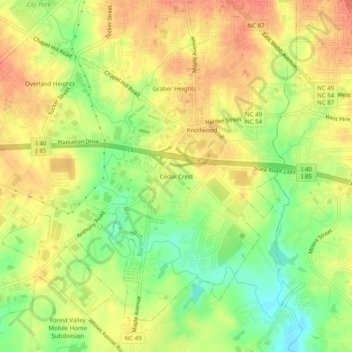
Name: Cedar Crest topographic map, elevation, terrain.
Average elevation: 183 m
Minimum elevation: 153 m
Maximum elevation: 204 m
Thank you for supporting this site ❤️
Make a donation
Make a donation
Other topographic maps
Click on a map to view its topography, its elevation and its terrain.
Woodruff Pond
United States > North Carolina > Alamance County > Burlington > Rockwood Acres
Average elevation: 204 m