Geolocate

Ciamis topographic map

Interactive map

Click on the map to display elevation.

About this map

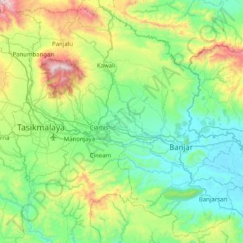
Name: Ciamis topographic map, elevation, terrain.

Location: Ciamis, West Java, Indonesia (-7.57469 108.16703 -7.05155 108.72346)

Average elevation: 390 m

Minimum elevation: 5 m

Maximum elevation: 1,726 m

Other topographic maps

Click on a map to view its topography, its elevation and its terrain.

Mount Kendang

Indonesia > West Java > Garut

Average elevation: 2,286 m

Rancamanyar

Indonesia > West Java > Bandung

Average elevation: 699 m

Papandayan

Indonesia > West Java > Garut

Average elevation: 2,319 m

Cimenyan

Indonesia > West Java > Bandung

Average elevation: 1,059 m

Purwakarta

Indonesia > West Java

Average elevation: 215 m

Pasir Lugay

Indonesia > West Java > Gardu

Average elevation: 483 m

Kersamanah

Indonesia > West Java > Kersamanah

Average elevation: 584 m