
Make a donation
South Yorkshire topographic map
Click on the map to display elevation.
Make a donation
About this map
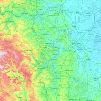
Name: South Yorkshire topographic map, elevation, terrain.
Average elevation: 123 m
Minimum elevation: 0 m
Maximum elevation: 630 m
Make a donation
Other topographic maps
Click on a map to view its topography, its elevation and its terrain.
Make a donation
Hallam Moors
United Kingdom > England > Derbyshire > Derbyshire Dales > Hathersage
Average elevation: 368 m
Make a donation
Make a donation
Robin Wood
United Kingdom > England > Derbyshire > South Derbyshire > Stanton by Bridge CP
Average elevation: 92 m
Pistern Hill
United Kingdom > England > Derbyshire > South Derbyshire > Smisby
Average elevation: 152 m
Make a donation
Heanor
United Kingdom > England > Derbyshire > Amber Valley
Samuel Lewis's A Topographical Dictionary of England, published in 1848, states that Heanor parish "abounds with coal and ironstone, both worked extensively, the collieries alone affording employment to more than 2000 persons. The town is pleasantly situated upon an eminence, on the road from Derby to…
Average elevation: 102 m
Repton Shrubs
United Kingdom > England > Derbyshire > South Derbyshire > Repton CP
Average elevation: 110 m
Make a donation
Crowden Great Brook
United Kingdom > England > Derbyshire > High Peak > Tintwistle > Crowden
Average elevation: 314 m
Make a donation
Kinder Scout
United Kingdom > England > Derbyshire > High Peak
To the north across the Snake Pass lie the high moors of Bleaklow and Black Hill, which are of similar elevation.
Average elevation: 555 m
Make a donation
Slaley
United Kingdom > England > Derbyshire > Derbyshire Dales > Matlock > Bonsall CP
Average elevation: 263 m
Newhall Wood
United Kingdom > England > Derbyshire > South Derbyshire > Newhall
Average elevation: 87 m
Denby Bottles
United Kingdom > England > Derbyshire > Amber Valley > Denby CP
Average elevation: 108 m
Make a donation
Make a donation
Lightwood
United Kingdom > England > Derbyshire > North East Derbyshire > Eckington
Average elevation: 168 m
Make a donation
Staunton Harold Reservoir
United Kingdom > England > Derbyshire > South Derbyshire > Melbourne CP
Average elevation: 93 m
Bolehill
United Kingdom > England > Derbyshire > Derbyshire Dales > Wirksworth CP
Average elevation: 220 m
Make a donation
Make a donation
Snake Pass
United Kingdom > England > Derbyshire > High Peak
Although Snake Pass is still the shortest route between Manchester and Sheffield, the more northerly Woodhead Pass, which is less steep and at a lower altitude, is now the primary road link between the two cities. Unlike Snake Pass, the Woodhead route is a trunk road. Traffic levels on both passes remained…
Average elevation: 488 m
Make a donation
Two Dales
United Kingdom > England > Derbyshire > Derbyshire Dales > Darley Dale CP > Darley Hillside
Average elevation: 189 m
Make a donation
Sutton Scarsdale
United Kingdom > England > Derbyshire > North East Derbyshire
Average elevation: 109 m
Starkholmes
United Kingdom > England > Derbyshire > Derbyshire Dales > Matlock
Average elevation: 175 m
Make a donation
Make a donation
Farley Wood
United Kingdom > England > Derbyshire > Derbyshire Dales > Matlock
Average elevation: 255 m
Foremark Reservoir
United Kingdom > England > Derbyshire > South Derbyshire > Foremark CP
Average elevation: 119 m
Magpie Mine
United Kingdom > England > Derbyshire > Derbyshire Dales > Ashford in the Water CP
Average elevation: 303 m
Make a donation
Make a donation
Ogston Reservoir
United Kingdom > England > Derbyshire > North East Derbyshire > Woolley Moor
Average elevation: 137 m
Make a donation
Make a donation
Doghole Wood
United Kingdom > England > Derbyshire > North East Derbyshire > Holymoorside
Average elevation: 142 m
Botany Bay
United Kingdom > England > Derbyshire > South Derbyshire > Rosliston
Average elevation: 95 m
Make a donation
Kinder Scout National Nature Reserve
United Kingdom > England > Derbyshire > High Peak > Hayfield
Average elevation: 513 m
Make a donation
Catcliff Wood
United Kingdom > England > Derbyshire > Derbyshire Dales > Bakewell CP
Average elevation: 173 m
Make a donation
Stanley
United Kingdom > England > Derbyshire > Erewash
The Church gates commemorate Queen Victoria's Golden Jubilee of 1887, and the churchyard contains a memorial (erected in 2004) to the five aircrew who lost their lives when an experimental high-altitude RAF Wellington Bomber disintegrated above Stanley in 1942 following a loss of cabin pressure.
Average elevation: 100 m
Make a donation
Rawson Green
United Kingdom > England > Derbyshire > Amber Valley > Kilburn CP
Average elevation: 109 m
Make a donation