
Nederweert topographic map
Interactive map
Click on the map to display elevation.
About this map
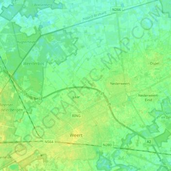
Name: Nederweert topographic map, elevation, terrain.
Location: Nederweert, Limburg, Nederland (51.23692 5.64400 51.33184 5.81170)
Average elevation: 32 m
Minimum elevation: 25 m
Maximum elevation: 40 m
Other topographic maps
Click on a map to view its topography, its elevation and its terrain.
Nationaal Park De Groote Peel
Nederland > Limburg > Nederweert
Nationaal Park De Groote Peel, 10e baan, Ospel, Nederweert, Limburg, Nederland, 6035RM, Nederland
Average elevation: 29 m
Schoor
Nederland > Limburg > Nederweert > Schoor
Schoor, Nederweert, Limburg, Nederland, 6031, Nederland
Average elevation: 33 m