
Thank you for supporting this site ❤️
Make a donation
Make a donation
Huis ter Heide topographic map
Click on the map to display elevation.
Thank you for supporting this site ❤️
Make a donation
Make a donation
About this map
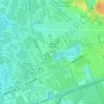
Name: Huis ter Heide topographic map, elevation, terrain.
Location: Huis ter Heide, Zeist, Utrecht, Nederland (52.10498 5.24325 52.13638 5.28234)
Average elevation: 12 m
Minimum elevation: 3 m
Maximum elevation: 36 m
Thank you for supporting this site ❤️
Make a donation
Make a donation
Other topographic maps
Click on a map to view its topography, its elevation and its terrain.