
Snoqualmie topographic map
Interactive map
Click on the map to display elevation.
About this map
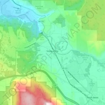
Name: Snoqualmie topographic map, elevation, terrain.
Location: Snoqualmie, King County, Washington, 98065, United States (47.50692 -121.89368 47.54875 -121.78295)
Average elevation: 213 m
Minimum elevation: 23 m
Maximum elevation: 721 m
Snoqualmie is located at 47°31′59″N 121°50′40″W / 47.53306°N 121.84444°W / 47.53306; -121.84444 (47.532934, -121.844341), at an elevation of 410 feet (120 m) above MSL.
Other topographic maps
Click on a map to view its topography, its elevation and its terrain.
Bothell
United States > Washington > King County
Bothell, King County, Washington, United States
Average elevation: 68 m
Seattle
United States > Washington > King County
Seattle, King County, Washington, United States
Average elevation: 40 m
Bellevue
United States > Washington > King County
Bellevue, King County, Washington, United States
Average elevation: 66 m
Factoria
United States > Washington > King County > Bellevue
Factoria, Bellevue, King County, Washington, 98006, United States
Average elevation: 75 m
Azure Lake
United States > Washington > King County
Azure Lake, King County, Washington, United States
Average elevation: 1,529 m
Sammamish
United States > Washington > King County
Sammamish, King County, Washington, United States
Average elevation: 97 m
Burien
United States > Washington > King County
Burien, King County, Washington, United States
Average elevation: 65 m
Maplewood
United States > Washington > King County > Renton
Maplewood, Renton, King County, Washington, 98058, United States
Average elevation: 102 m
Lake City Memorial Triangle
United States > Washington > King County > Seattle
Lake City Memorial Triangle, 12354, Lake City, Seattle, King County, Washington, 98125, United States
Average elevation: 61 m
White Center
United States > Washington > King County
White Center, King County, Washington, 98146, United States
Average elevation: 58 m
Stevens Pass
United States > Washington > King County
Stevens Pass, King County, Washington, United States
Average elevation: 1,387 m
Grotto
United States > Washington > King County
Grotto, King County, Washington, 98224, United States
Average elevation: 528 m
Moira Lake
United States > Washington > King County
Moira Lake, King County, Washington, United States
Average elevation: 1,303 m
Jones Lake
United States > Washington > King County > Black Diamond
Jones Lake, Black Diamond, King County, Washington, United States
Average elevation: 210 m
Woodinville
United States > Washington > King County
Woodinville, King County, Washington, United States
Average elevation: 73 m
Annette Lake
United States > Washington > King County
Annette Lake, King County, Washington, United States
Average elevation: 1,318 m
Renton
United States > Washington > King County
Renton, King County, Washington, United States
Average elevation: 83 m
Shoreline
United States > Washington > King County
Shoreline, King County, Washington, 98155, United States
Average elevation: 99 m
Auburn
United States > Washington > King County
Auburn, King County, Washington, United States
Average elevation: 88 m
Five Mile Lake
United States > Washington > King County > Lakeland South
Five Mile Lake, Lakeland South, King County, Washington, United States
Average elevation: 115 m
Woodinville
United States > Washington > King County > Woodinville > Woodinville
Woodinville, King County, Washington, 98072, United States
Average elevation: 80 m
SeaTac
United States > Washington > King County
SeaTac, King County, Washington, United States
Average elevation: 60 m
Mercer Island
United States > Washington > King County > Mercer Island
Mercer Island, King County, Washington, 98040, United States
Average elevation: 39 m
Green Lake
United States > Washington > King County > Seattle
Green Lake, Seattle, King County, Washington, 98103, United States
Average elevation: 75 m
Kirkland
United States > Washington > King County
Kirkland, King County, Washington, United States
Average elevation: 58 m
Kent
United States > Washington > King County
Kent, King County, Washington, United States
Average elevation: 87 m
Maple Valley
United States > Washington > King County
Maple Valley, King County, Washington, 98038, United States
Average elevation: 160 m
Kenmore
United States > Washington > King County
Kenmore, King County, Washington, 98028, United States
Average elevation: 59 m
Issaquah
United States > Washington > King County
Issaquah, King County, Washington, United States
Average elevation: 164 m
Redmond
United States > Washington > King County
Redmond, King County, Washington, United States
Average elevation: 72 m
Federal Way
United States > Washington > King County
Federal Way, King County, Washington, United States
Average elevation: 81 m