
Alto topographic map
Interactive map
Click on the map to display elevation.
About this map
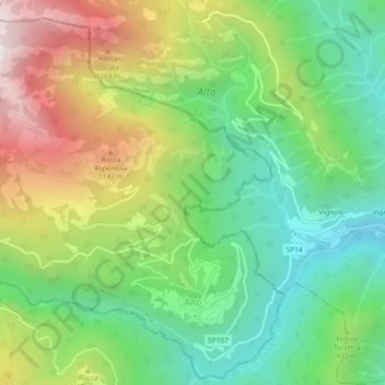
Name: Alto topographic map, elevation, terrain.
Location: Alto, Cuneo, Piedmont, Italy (44.10234 7.96790 44.13443 8.01421)
Average elevation: 776 m
Minimum elevation: 317 m
Maximum elevation: 1,510 m
Other topographic maps
Click on a map to view its topography, its elevation and its terrain.
Bersia
Italy > Piedmont > Cuneo > San Damiano Macra
Bersia, San Damiano Macra, Cuneo, Piedmont, 12020, Italy
Average elevation: 1,336 m
Fre
Italy > Piedmont > Cuneo > Montemale di Cuneo
Fre, Montemale di Cuneo, Cuneo, Piedmont, Italy
Average elevation: 997 m
Giardino Famiglia Allemandi
Italy > Piedmont > Cuneo > Villar San Costanzo > Pramallé
Giardino Famiglia Allemandi, Pramallé, Villar San Costanzo, Cuneo, Piedmont, Italy
Average elevation: 654 m
Punta Razil
Italy > Piedmont > Cuneo > Bagnolo Piemonte
Punta Razil, Bagnolo Piemonte, Cuneo, Piedmont, Italy
Average elevation: 2,008 m
Pontechianale
Pontechianale, Cuneo, Piedmont, Italy
Average elevation: 2,447 m
Limone Piemonte
Limone Piemonte, Cuneo, Piedmont, 12015, Italy
Average elevation: 1,619 m