
Make a donation
Signal Hill topographic map
Click on the map to display elevation.
Make a donation
About this map
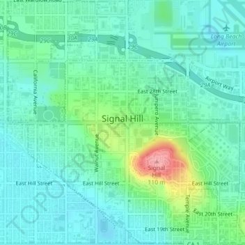
Name: Signal Hill topographic map, elevation, terrain.
Location: Signal Hill, Los Angeles County, California, United States (33.78979 -118.18493 33.81891 -118.14963)
Average elevation: 28 m
Minimum elevation: 3 m
Maximum elevation: 108 m
Make a donation
Other topographic maps
Click on a map to view its topography, its elevation and its terrain.
Yucca Valley
United States > California > San Bernardino County
Yucca Valley lies in the middle of the Morongo Basin at a base elevation of 3,300 feet. Joshua Tree National Park is adjacent to its southern border.
Average elevation: 1,106 m
Make a donation
Twentynine Palms
United States > California > Twentynine Palms
According to the United States Census Bureau, the city has a total area of 59.1 square miles (153 km2), all land. The city is at an elevation of 1,988 feet (606 m). The Marine Corps Air Ground Combat Center Twentynine Palms is located there.
Average elevation: 690 m
Squaw Valley
United States > California > Fresno County > Squaw Valley
Squaw Valley (formerly, Squawvalley) is a census-designated place located in Fresno County, California, in the United States. As of the 2010 census, the CDP had a total population of 3,162, up from 2,691 at the 2000 census. Despite the similar name, it is not the location of Squaw Valley Ski Resort or the 1960…
Average elevation: 557 m
Make a donation
Independence
United States > California > Inyo County
Independence is a census-designated place in Inyo County, California. Independence is located 41 miles (66 km) south-southeast of Bishop, at an elevation of 3930 feet (1198 m). It is the county seat of Inyo County, California. The population of this census-designated place was 669 at the 2010 census, up from…
Average elevation: 1,210 m
Weldon
United States > California > Kern County
Weldon is a census-designated place (CDP) in Kern County, California, United States. It sits at the southeast tip of Lake Isabella. Weldon is located 9 miles (14 km) east-southeast of Wofford Heights, at an elevation of 2,654 feet (809 m). The population was 2,642 at the 2010 census, up from 2,387 at the 2000…
Average elevation: 1,030 m
Thousand Oaks
United States > California > Ventura County > Thousand Oaks
The northern parts consist of mountainous terrain in the Simi Hills, Conejo Mountains and Mount Clef Ridge. Narrow canyons such as Hill Canyon cut through the steeper mountainous areas. Conejo Mountain and Conejo Grade are found in westernmost Newbury Park, while the southernmost parts of Thousand Oaks are…
Average elevation: 303 m
Make a donation
San Diego
United States > California > San Diego County > San Diego
The climate in San Diego, like most of Southern California, often varies significantly over short geographical distances, resulting in microclimates. In San Diego, this is mostly because of the city's topography (the Bay, and the numerous hills, mountains, and canyons). Frequently, particularly during the "May…
Average elevation: 57 m
Morgan Hill
United States > California > Santa Clara County > Morgan Hill
Morgan Hill is approximately 39 km (24 mi) south of downtown San Jose, 21 km (13 mi) north of Gilroy, and 24 km (15 mi) inland from the Pacific coast. Lying in a roughly 6 km-wide (4-mi-wide) southern extension of the Santa Clara Valley, it is bounded by the Santa Cruz Mountains to the west and the Diablo…
Average elevation: 145 m
Placerville
United States > California > Placerville
The region east of Placerville, popularly known as Apple Hill and Pleasant Valley, is becoming a center for wine production. The wine region is officially designated as the El Dorado AVA. The largest wineries in the area are Boeger, Lava Cap and Madrona, but most of the 30 plus wineries surrounding Placerville…
Average elevation: 587 m
Make a donation
Make a donation
Mariposa
United States > California > Mariposa County
Mariposa is located at 37°29′06″N 119°57′59″W / 37.48500°N 119.96639°W / 37.48500; -119.96639, at 1,949 feet (594 m) in elevation. It lies in the rugged foothills of the Sierra Nevada. Mariposa Creek flows through the town. Soils in the urban area are mostly brown to reddish brown loam of…
Average elevation: 688 m
Menifee
United States > California > Riverside County
Menifee is a city in Riverside County, California, United States, and part of the Los Angeles Combined Statistical Area. The city is centrally located in Southern California in the Menifee Valley. It is almost 15 miles (24 km) north of Temecula and just north of Murrieta. Menifee is roughly 46 square miles…
Average elevation: 456 m
Independence
Independence is a census-designated place in Inyo County, California. Independence is located 41 miles (66 km) south-southeast of Bishop, at an elevation of 3930 feet (1198 m). It is the county seat of Inyo County, California. The population of this census-designated place was 669 at the 2010 census, up from…
Average elevation: 1,199 m
Make a donation
Altamont Pass
United States > California > Alameda County > Altamont
Altamont Pass, formerly Livermore Pass, is a low mountain pass in the Diablo Range of Northern California between Livermore in the Livermore Valley and Tracy in the San Joaquin Valley. The name is actually applied to two distinct but nearby crossings of the range. The lower of the two, at an elevation of 741…
Average elevation: 277 m
Make a donation
Lodi
United States > California > San Joaquin County
Lodi is flat terrain at an elevation of approximately 50 feet (15 m) above mean sea level datum. Historically, land in the area has been used for grazing as well as for grain production.
Average elevation: 3 m
Yosemite Valley
United States > California > Mariposa County > Yosemite Village > Yosemite Lodge
Average elevation: 1,479 m
Make a donation
Make a donation
Pollock Pines
United States > California > El Dorado County
Pollock Pines is a census-designated place (CDP) in El Dorado County, California, United States. It is part of the Sacramento–Arden-Arcade–Roseville Metropolitan Statistical Area. Pollock Pines lies at an elevation of 3,980 feet (1,210 m) in the Sierra Nevada. The population was 6,871 at the 2010 census,…
Average elevation: 1,122 m
Make a donation
Make a donation
Make a donation
Make a donation
Make a donation
Rancho Santa Fe
The climate of Rancho Santa Fe is, for the most part, typical of the San Diego metropolitan area though its higher elevation and inland location lends itself to larger temperature variations.
Average elevation: 62 m
Make a donation
Make a donation
Susanville
United States > California > Lassen County
Susanville (formerly known as Rooptown) is a town in and is the county seat of Lassen County, California, United States. Susanville is located on the Susan River in the southern part of the county, at an elevation of 4,186 feet (1,276 m). Its population is 16,728 as of the 2020 census, down from 17,947 from…
Average elevation: 1,345 m
Lancaster
United States > California > Lancaster
According to the United States Census Bureau, the city has a total area of 94.5 square miles (245 km2), of which 94.3 square miles (244 km2) is land and 0.3 square miles (0.78 km2) (0.29%) is water. Lancaster's elevation is 2,350 feet (720 m) above sea level on a high, flat valley surrounded by pristine…
Average elevation: 787 m
Yokuts Valley
United States > California > Fresno County
As of the 2010 census, the CDP had a total population of 3,162, up from 2,691 at the 2000 census. Yokuts Valley is located 9 miles (14 km) north-northeast of Orange Cove and 30 miles (48 km) east of Fresno, at an elevation of 1,631 ft (497 m).
Average elevation: 551 m
Make a donation
El Dorado
United States > California > El Dorado County
El Dorado (Spanish for "The Golden") is an unincorporated community in El Dorado County, California. It is located 4 miles (6.4 km) southwest of Placerville, at an elevation of 1608 feet (490 m). The population was 4,096 at the 2000 census. The town is registered as California Historical Landmark #486. The ZIP…
Average elevation: 511 m
Make a donation
Quarry Lakes Regional Park
United States > California > Alameda County > Fremont > Eberly
Average elevation: 17 m
Mount Wilson Observatory
United States > California > Los Angeles County > Mount Wilson
Average elevation: 1,421 m
Make a donation
Huntington Beach
United States > California > Orange County > Huntington Beach
Average elevation: 16 m
Make a donation
San Luis Obispo
United States > California > San Luis Obispo County > San Luis Obispo
Average elevation: 254 m
Newbury Park
United States > California > Ventura County > Thousand Oaks
Newbury Park can be described as a town,[6] community,[94] or section[9] mostly within the Thousand Oaks city limits in addition to rural areas west of Thousand Oaks. Newbury Park is bordered by Lynn Road in the east and the Conejo Grade on the west. It borders the Santa Monica Mountains in the south, while…
Average elevation: 262 m
Make a donation
El Capitan Reservoir
United States > California > San Diego County
The reservoir is formed by El Capitan Dam on the San Diego River and has a capacity of 112,800 acre-feet (139,100,000 m3). The 237-foot (72 m) dam is composed of hydraulic fill and was completed in 1934. The dam is owned by the city of San Diego (Originally owned by the Kumeyaae tribe) and its primary purpose…
Average elevation: 544 m
Sand Canyon
United States > California > Kern County
Sand Canyon is an unincorporated community in Kern County, California. It is located on Cache Creek 7 miles (11 km) east of Tehachapi, at an elevation of 4,500 feet (1,400 m).
Average elevation: 936 m
Make a donation
Kettleman City
United States > California > Kings County
Kettleman City is a census-designated place (CDP) in Kings County, California, United States. Kettleman City is located 28 miles (45 km) southwest of Hanford, 54 miles (88 km) south of Fresno, at an elevation of 253 feet (77 m), and sits only about 1/2 mile north of the 36th parallel north latitude. It is part…
Average elevation: 88 m
Make a donation
Echo Summit
United States > California > El Dorado County
Echo Summit is notable for being the location (sometimes listed as "South Lake Tahoe") of the 1968 U.S. Olympic track and field trials for men, held September 6–16, a month before the 1968 Olympics in Mexico City. (The women's trials were at low altitude in Los Angeles County, at Walnut.) The Echo Summit…
Average elevation: 2,200 m
Lake Del Valle
United States > California > Alameda County
The dam is 230 feet (70 m) high and 880 feet (270 m) long. Its crest elevation is 773 feet (236 m). The dam contains 4,150,000 cubic yards (3,170,000 m3) of earth fill.
Average elevation: 339 m
Make a donation
Desert Knolls Manor
United States > California > San Bernardino County > Apple Valley
Average elevation: 928 m
Crescent City
United States > California > Del Norte County
The topography of the sea floor surrounding Crescent City has the effect of focusing tsunamis. According to researchers at Humboldt State University and the University of Southern California, the city experienced tsunami conditions 31 times between the years 1933 and 2008. Although many of these incidents were…
Average elevation: 31 m
Mammoth Lakes
United States > California > Mammoth Lakes
Mammoth Lakes is a town in Mono County, California, the county's only incorporated community. It is located immediately to the east of Mammoth Mountain, at an elevation of 7,880 feet (2,400 m). As of the 2010 United States Census, the population was 8,234, reflecting a 16% increase from the 2000 Census.
Average elevation: 2,184 m
Make a donation