
Thank you for supporting this site ❤️
Make a donation
Make a donation
St. James topographic map
Click on the map to display elevation.
Thank you for supporting this site ❤️
Make a donation
Make a donation
About this map
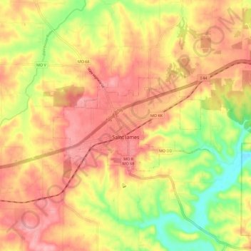
Name: St. James topographic map, elevation, terrain.
Location: St. James, Phelps County, Missouri, 65559, United States (37.97764 -91.66950 38.02410 -91.55776)
Average elevation: 304 m
Minimum elevation: 235 m
Maximum elevation: 351 m
Thank you for supporting this site ❤️
Make a donation
Make a donation
Other topographic maps
Click on a map to view its topography, its elevation and its terrain.