
Make a donation
Iowa County topographic map
Click on the map to display elevation.
Make a donation
About this map
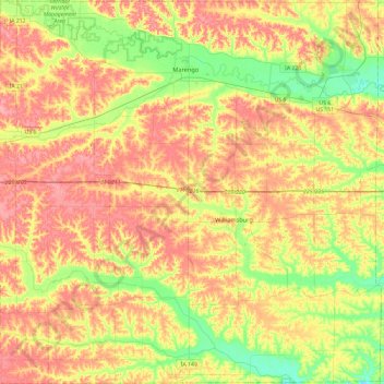
Name: Iowa County topographic map, elevation, terrain.
Location: Iowa County, Iowa, United States (41.50959 -92.29987 41.86295 -91.82705)
Average elevation: 249 m
Minimum elevation: 206 m
Maximum elevation: 288 m
Make a donation
Other topographic maps
Click on a map to view its topography, its elevation and its terrain.
Make a donation
Make a donation
Make a donation
Make a donation
Make a donation
Make a donation
Mississippi River
United States > Iowa > Louisa County > New Boston
The uppermost lock and dam on the Upper Mississippi River is the Upper St. Anthony Falls Lock and Dam in Minneapolis. Above the dam, the river's elevation is 799 feet (244 m). Below the dam, the river's elevation is 750 feet (230 m). This 49-foot (15 m) drop is the largest of all the Mississippi River locks…
Average elevation: 169 m
Make a donation
Make a donation
Mississippi River
United States > Iowa > Scott County > Pleasant Valley Township
The uppermost lock and dam on the Upper Mississippi River is the Upper St. Anthony Falls Lock and Dam in Minneapolis. Above the dam, the river's elevation is 799 feet (244 m). Below the dam, the river's elevation is 750 feet (230 m). This 49-foot (15 m) drop is the largest of all the Mississippi River locks…
Average elevation: 179 m
Make a donation
Make a donation
Mississippi River
United States > Iowa > Dubuque County > Dubuque > Eagle Point
The uppermost lock and dam on the Upper Mississippi River is the Upper St. Anthony Falls Lock and Dam in Minneapolis. Above the dam, the river's elevation is 799 feet (244 m). Below the dam, the river's elevation is 750 feet (230 m). This 49-foot (15 m) drop is the largest of all the Mississippi River locks…
Average elevation: 200 m
Make a donation
Make a donation
Make a donation
Make a donation
Make a donation
Iowa City
United States > Iowa > Johnson County > Iowa City
The elevation at the Iowa City Municipal Airport is 668 ft (203.6 m) above sea level.
Average elevation: 225 m
Make a donation
Make a donation
Saint Anthony
United States > Iowa > Marshall County > St. Anthony > Saint Anthony
Average elevation: 317 m
Clear Lake
United States > Iowa > Cerro Gordo County > Clear Lake > Clear Lake
Average elevation: 373 m
Make a donation
Coon River Wildlife Management Area
United States > Iowa > Winneshiek County > Sattre
Average elevation: 295 m
Make a donation