
Port Talbot topographic map
Click on the map to display elevation.
Port Talbot
Port Talbot sea floor topography ranges from 0 to 15 metres (0 to 50 ft) within Swansea Bay. There are many patches within the bay including the North Kenfig patches, green grounds, outer green grounds, madjoe and stalheim. These patches are created from faults, hollows, general topography and other factors. Sea depth around Port Talbot is 10 to 50 metres (35 to 165 ft) with increasing depth with increasing distance from the coast. There are two beaches within Port Talbot: Aberafan and Morfa. The sand at both beaches is yellow and semi-shell rich. The tide in the area has a harmonic prediction which means it can be predicted easy and has repeatable tide heights every year. The outer bay area and sea area near Port Talbot Pier has a tidal stream with no harmonic prediction. A tidal stream (or tidal current) is an alternating horizontal movement of water associated with the rise and fall of the tide caused by tide-producing forces. This means that the tide cannot be accurately predicted due to additional factors like currents, rip current, river mouths and precipitation. There are also two major dumping grounds within the bay. These are areas where sand is collected for the construction industry. Port Talbot docks is a deep water harbour which allows large cargo ships to dock into the area.
About this map
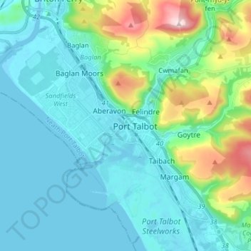
Name: Port Talbot topographic map, elevation, terrain.
Average elevation: 76 m
Minimum elevation: -4 m
Maximum elevation: 370 m
Other topographic maps
Click on a map to view its topography, its elevation and its terrain.