
Thank you for supporting this site ❤️
Make a donation
Make a donation
Puketāpapa topographic map
Click on the map to display elevation.
Thank you for supporting this site ❤️
Make a donation
Make a donation
About this map
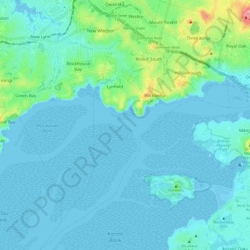
Name: Puketāpapa topographic map, elevation, terrain.
Location: Puketāpapa, Auckland, New Zealand (-36.98924 174.68320 -36.89485 174.77546)
Average elevation: 22 m
Minimum elevation: -2 m
Maximum elevation: 164 m
Thank you for supporting this site ❤️
Make a donation
Make a donation
Other topographic maps
Click on a map to view its topography, its elevation and its terrain.
Thank you for supporting this site ❤️
Make a donation
Make a donation
Thank you for supporting this site ❤️
Make a donation
Make a donation