
Thank you for supporting this site ❤️
Make a donation
Make a donation
Guilheiro topographic map
Click on the map to display elevation.
Thank you for supporting this site ❤️
Make a donation
Make a donation
About this map
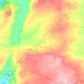
Name: Guilheiro topographic map, elevation, terrain.
Location: Guilheiro, Trancoso, Guarda, Portugal (40.88004 -7.43037 40.92182 -7.37885)
Average elevation: 865 m
Minimum elevation: 719 m
Maximum elevation: 953 m
Thank you for supporting this site ❤️
Make a donation
Make a donation
Other topographic maps
Click on a map to view its topography, its elevation and its terrain.